Great surf tomorrow, easing through the rest of the week

South-east Queensland and Northern NSW Surf Forecast by Craig Brokensha (issued Friday 11th May)
Best Days: Tuesday morning, early Wednesday and Thursday northern NSW, Friday and Saturday mornings northern NSW
Recap
Small to tiny leftovers Saturday across all locations, while an acute pulse of new S'ly swell came in well across most breaks, but missed others as is the case with these swells. Magnets across the northern NSW coast saw 4-6ft sets with great morning offshore winds, easing later in the day.
The Goldy saw 2-3ft sets across south magnets, tiny elsewhere.
This morning we were in between pulses across the Goldy and northern extent of the northern NSW coast, while the Mid North Coast saw some new S/SE swell filling in, providing large sets at south magnets. This swell is now making its way up the coast though with poor winds.
Today’s Forecaster Notes are brought to you by Rip Curl
This week and weekend (May 15 – 20)
These notes will be brief as Ben’s on holidays.
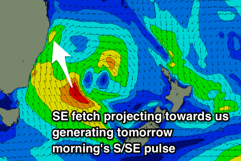 Today's building S/SE swell across the Mid North Coast, pushing its way further north is due to a good fetch of strong S/SE winds being projected up the East Coast as the Tasman Low moved east.
During yesterday afternoon we saw a good fetch of SE gales projected on top of the active sea state produced by pre-established S/SE winds, generating a large S/SE groundswell pulse for tomorrow morning.
Swell magnets on the North Coast should see 6-8ft sets early, easing back slowly through the day, while the Gold Coast should provide better 3ft to occasional 4ft waves across open beaches (smaller on the points and Sunny Coast and larger at south magnets).
Conditions look great as an approaching from front from the south tips winds back to the W/SW through tomorrow morning, swinging SW before lunch and then S/SW-S into the afternoon.
There'll still be plenty of size left across northern NSW Wednesday morning as a fetch of strong S/SE winds remain in our swell window this afternoon and evening, before starting to shift more away from us and breaking down tomorrow.
South magnets are due to ease back from 4-5ft+ Wednesday morning (2-3ft Gold Coast open beaches – smaller Sunny Coast), while a fresh pulse of S/SE swell is due Thursday from a front pushing up into the Tasman Sea Tuesday evening and Wednesday morning.
This will be mixed also with a less consistent S'ly groundswell produce by the parent polar low generating a fetch of gale to severe-gale W/SW winds south of Tassie this evening and tomorrow.
A mix of swells to 3ft+ is due Thursday morning, kicking to 3-4ft through the afternoon. The Goldy is only due to be small to tiny with these additional swells.
Winds on Wednesday morning will be OK at dawn and from the SW, tending S/SE through the day, with S/SW-SW tending SE winds on Thursday.
Friday morning looks the cleanest after tomorrow morning's offshore with a light W/NW breeze and afternoon sea breezes, with fun easing 3ft sets across south magnets.
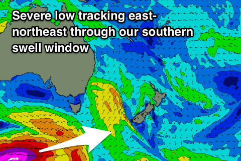 Very late in the day and more so Saturday morning, a strong long-period S'ly groundswell is expected across the northern NSW coast.
The groundswell is being under forecast by the wave models, with it being generated by a very impressive polar low over the coming days.
We'll see this polar low form south of the country, generating a fetch of severe-gale to storm-force W'ly winds in our far southern swell window.
The low will project favourably east-northeast up towards New Zealand while weakening slightly Wednesday and then stalling slightly Thursday.
The long-period fore-runners upwards of 20s are due to arrive late Friday across the Mid North Coast, peaking Saturday morning to 4-5ft or so at south magnets, easing through the day.
Now these long-period S'ly groundswells always do funky things and focus into some places and not into others, to expect to do a bit of driving if trying to maximise the swell potential off this system.
Conditions will be great with a light morning W/NW breeze, giving into afternoon sea breezes, and a stronger S'ly change on the Mid North Coast.
This change will be linked to a strong cold outbreak in the southern Tasman Sea, bringing large southerly swells into early next week, but more on this Wednesday.