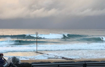
Don’t get too worked up about the weekend’s large, windy surf, as the best waves from this synoptic sequence will certainly happen after the main event. More in the Forecaster Notes.
Primary tabs
/reports/forecaster-notes/sydney-hunter-illawarra/2020/05/20/coupla-days-large-windy-waves-ahead
thermalben
Wednesday, 20 May 2020
/reports/forecaster-notes/sydney-hunter-illawarra/2020/05/18/fascinating-synoptics-the-next-coupla
thermalben
Monday, 18 May 2020
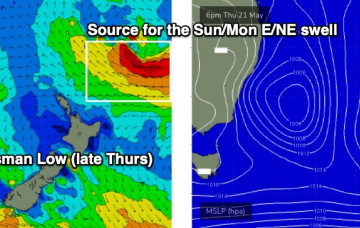
The short term forecast period is all about lully, inconsistent, long range E/NE swells. But there's a series of large S'ly swells on the cards too. More in the Forecaster Notes.

/reports/forecaster-notes/sydney-hunter-illawarra/2020/05/15/extended-run-out-the-eastern-quadrant
thermalben
Friday, 15 May 2020
So, here’s the new swell, punching slightly higher than forecast though well within trend expectations. More in the Forecaster Notes.
/reports/forecaster-notes/sydney-hunter-illawarra/2020/05/13/nice-run-swell-ahead
thermalben
Wednesday, 13 May 2020
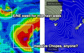
The good news is that there’s been a small upgrade in a new E/NE swell. More in the Forecaster Notes.
/reports/forecaster-notes/sydney-hunter-illawarra/2020/05/11/swell-sources-galore-though-none-em
thermalben
Monday, 11 May 2020
Lots of fun swells on the way, holding through the weekend. More in the Forecaster Notes.

/reports/forecaster-notes/sydney-hunter-illawarra/2020/05/08/reasonable-surf-potential-most-days
thermalben
Friday, 8 May 2020
Model guidance suggests a slow weekend of tiny waves, but I think it’s quite a way off the mark. More in the Forecaster Notes.
/reports/forecaster-notes/sydney-hunter-illawarra/2020/05/06/coupla-swell-sources-keep-tab
thermalben
Wednesday, 6 May 2020
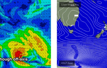
In general, the trend for the next few days will be small, slow and clean. But there are some interesting swell sources on the boil. More in the Forecaster Notes.

/reports/forecaster-notes/sydney-hunter-illawarra/2020/05/04/make-the-most-the-next-few-days-flukey
thermalben
Monday, 4 May 2020
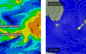
A strong front racing through the lower Tasman Sea today will provide a reinforcing S/SE swell for the coming days. More in the Forecaster Notes.
/reports/forecaster-notes/sydney-hunter-illawarra/2020/05/01/and-it-came-or-coming-the-south
thermalben
Friday, 1 May 2020
The Long Wave Trough currently responsible for cold weather, gale force winds and cold temps won’t push into our south swell window until Saturday morning. More in the Forecaster Notes.
/reports/forecaster-notes/sydney-hunter-illawarra/2020/04/29/punchy-ne-swell-then-strong-sly-run
thermalben
Wednesday, 29 April 2020
As mentioned above (and as also commented on in Wednesday’s notes) the models have stalled the west-east progression of the Long Wave Trough. More in the Forecaster Notes.