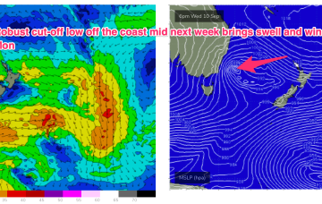
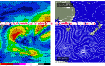
Swell generating winds are poorly aligned and with the weakening system racing through the swell window we’re only expecting a small payload of S swell from this progression.
Primary tabs
/reports/forecaster-notes/sydney-hunter-illawarra/2025/09/15/small-s-pulses-week-rapid-wind-changes
freeride76
Monday, 15 September 2025
/reports/forecaster-notes/sydney-hunter-illawarra/2025/09/12/clean-fun-the-s-over-the-weekend-few
freeride76
Friday, 12 September 2025
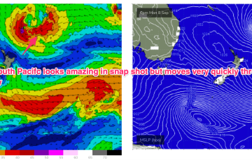
Nothing major on the radar next week so we’ll be relying on small S pulses for a wave at S magnets.
/reports/forecaster-notes/sydney-hunter-illawarra/2025/09/10/coastal-low-brings-rapid-spike-in-big
Coastal low brings a rapid spike in big, windy surf easing rapidly to fun, clean surf on the weekend
freeride76
Wednesday, 10 September 2025
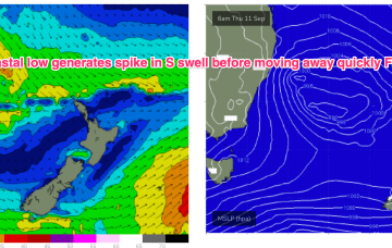
We should then see a low centred just off Sydney rapidly deepen o/night into tomorrow morning with W’ly gales north of the low and SW-S gales south of the low. The low moves away quickly tomorrow with SW-S gales tending to strong winds from the same direction through the day.
/reports/forecaster-notes/sydney-hunter-illawarra/2025/09/08/coastal-low-dominate-the-week-large
thermalben
Monday, 8 September 2025
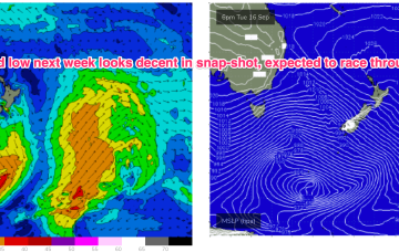
The main feature on this week's synoptic charts is a cut-off low that’s expected to intensify off Southern NSW around Thursday, delivering a rapid increase in short range southerly swell and associated SW tending S’ly winds.
/reports/forecaster-notes/sydney-hunter-illawarra/2025/09/05/nlies-developing-the-weekend-robust-s
freeride76
Friday, 5 September 2025
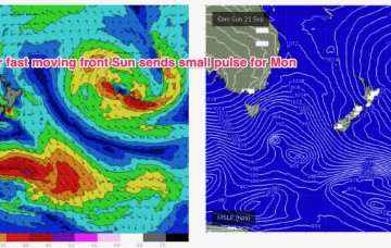
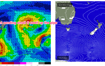
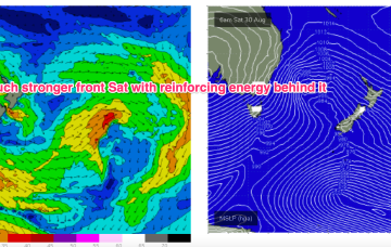
Quite a strong front and deep low passes through the southern extremity of the Tasman Sea swell window Mon/Tues- with S swell likely to build Wed or Thurs.
/reports/forecaster-notes/sydney-hunter-illawarra/2025/09/02/small-and-clean-short-term-next-week
freeride76
Wednesday, 3 September 2025
Small S swells continue to be the main swell trains.
/reports/forecaster-notes/sydney-hunter-illawarra/2025/09/01/small-s-pulses-week-mostly-offshore
freeride76
Monday, 1 September 2025
An ice shelf fetch over the weekend looked strong on paper but the extent to which winter sea ice has hindered swell generation remains a key source of uncertainty.
/reports/forecaster-notes/sydney-hunter-illawarra/2025/08/28/strong-cold-front-brings-spike-in-s
freeride76
Friday, 29 August 2025
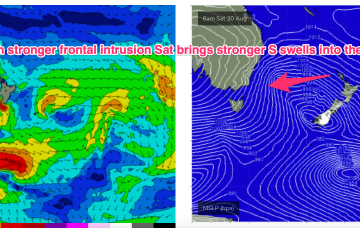
Still on track for a wintry blast this weekend as a strong cold front tied to an intense low currently west of Tasmania sweeps up over the SE overnight and enters the Tasman early tomorrow morning.
/reports/forecaster-notes/sydney-hunter-illawarra/2025/08/26/winter-blast-ahead-end-the-season
freeride76
Wednesday, 27 August 2025
Winds shift W’ly as the initial frontal system sweeps across NSW tomorrow, with a stronger front and low moving up over NSW and then entering the Tasman with a vengeance into the weekend.
/reports/forecaster-notes/sydney-hunter-illawarra/2025/08/24/quality-e-swells-fade-through-the-week
freeride76
Monday, 25 August 2025
These low centres are focussing areas of E’ly infeed along the trough line- perfectly aimed at east coast targets.