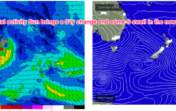
We’ll see some swell from this pattern, first from the initial short range S swell and then some better quality S/SE swell as the surface low retrogrades from near the South Island back into the Tasman. Read on for details and a sketch of the Xmas week.
Primary tabs
/reports/forecaster-notes/south-east-queensland-northern-new-south-wales/2024/12/16/swells-around-the
freeride76
Monday, 16 December 2024
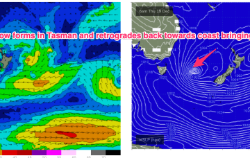
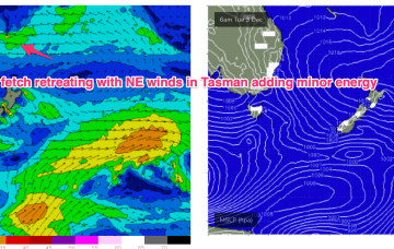
/reports/forecaster-notes/south-east-queensland-northern-new-south-wales/2024/12/13/definitely-more
freeride76
Friday, 13 December 2024
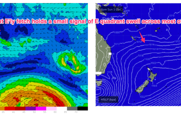
Latest model runs have amplified this trough and a resulting trough of low pressure in the Tasman. There’s still some model divergence to get through so expect some revisions but odds are firming off a sizey S tending S/SE swell event from Thurs, as the trough deepens in the Central Tasman.
/reports/forecaster-notes/south-east-queensland-northern-new-south-wales/2024/12/11/few-small-waves
freeride76
Wednesday, 11 December 2024
On the back of a monsoonal surge models are starting to look interested in low pressure development between PNG, the Solomons and Vanuatu which may indicate the first real tropical developments of the season. Still too early to have any expectations on surf potential from this area but we will keep our eyes on it.
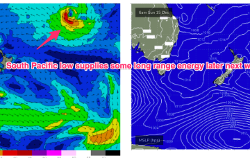
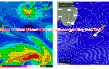
/reports/forecaster-notes/south-east-queensland-northern-new-south-wales/2024/12/09/good-week-xmas
freeride76
Monday, 9 December 2024
A very weak troughy pattern is unfolding this week with a weak high pressure (1016hPa) cell moving into the Tasman today as a trough stalls about the Far North Coast. Another trough tomorrow brings a shallow S’ly change which again looks to stall out on the North Coast before another weak high cell moves into the Tasman late this week. In short, no major swells expected.
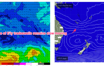
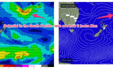
/reports/forecaster-notes/south-east-queensland-northern-new-south-wales/2024/12/05/ely-tradeswell
freeride76
Friday, 6 December 2024
Longer term and we’ll be watching the South Pacific Convergence Zone for signs of low pressure development near Fiji later next week, possibly even retrograding back towards the Australian continent.
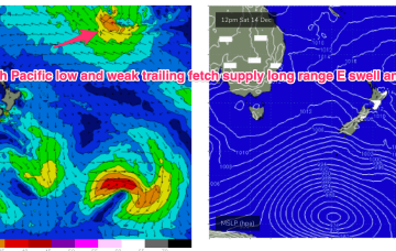
/reports/forecaster-notes/south-east-queensland-northern-new-south-wales/2024/12/04/trade-swell-just
freeride76
Wednesday, 4 December 2024
A long tradewind fetch anchored by a 1024hPa high in the central SW Pacific is slowly retreating eastwards with a weak high cell expected to migrate into the Tasman overnight and tomorrow in the wake of a shallow trough now moving up the NSW Coast and expected to stall and wash out around the lower reaches of the MNC.
/reports/forecaster-notes/south-east-queensland-northern-new-south-wales/2024/12/02/ely-tradeswells
freeride76
Monday, 2 December 2024
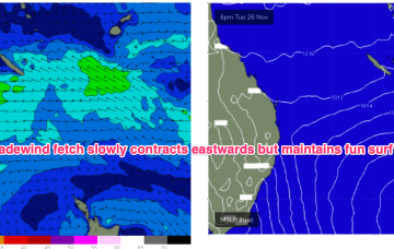
A shallow, troughy change mid-week looks to stall around Seal Rocks before weak high pressure moves into the Tasman. No major swells this week, so we’ll be relying on our persistent trade-swell, which looks to ease off mid-week as the fetch retreats eastwards.
/reports/forecaster-notes/south-east-queensland-northern-new-south-wales/2024/11/29/more-fun
freeride76
Friday, 29 November 2024
Tradewinds keep chugging away supplying fun surf over the weekend.
/reports/forecaster-notes/south-east-queensland-northern-new-south-wales/2024/11/27/steady-drumbeat
freeride76
Wednesday, 27 November 2024
A tradewind flow focussed around the New Caledonia area and out into the South Pacific slot will maintain fun E’ly tradewind surf in the sub-tropics.
/reports/forecaster-notes/south-east-queensland-northern-new-south-wales/2024/11/25/persistent-ely
freeride76
Monday, 25 November 2024
As a result, we’re looking at small NE windswells for temperate NSW, with workable trade swells for the sub-tropics and a marginal amount of that swell filtering down to temperate regions.