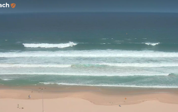
This is a tricky, low confidence event so I’d be reluctant to pack the car overnight for a pre-dawn mission - but it’ll be well worth keeping an eye on things.
Primary tabs
/reports/forecaster-notes/sydney-hunter-illawarra/2025/03/24/two-complex-unusual-swell-events-the
thermalben
Monday, 24 March 2025
/reports/forecaster-notes/sydney-hunter-illawarra/2025/03/21/not-much-the-weekend-some-flukey-s-swell
freeride76
Friday, 21 March 2025
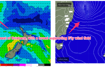
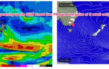
Tues offers some potential with models picking up some long period S/SE groundswell generated by a slow moving polar low around the edge of the Antarctic ice shelf in the vicinity of the Ross Sea.
/reports/forecaster-notes/sydney-hunter-illawarra/2025/03/19/average-period-ahead-the-long-terms
thermalben
Wednesday, 19 March 2025
Both swell sources will ease slowly through Friday though early morning should still show a healthy percentage of Thursday’s size
/reports/forecaster-notes/sydney-hunter-illawarra/2025/03/17/easing-surf-tues-then-small-pulse-thurs
thermalben
Monday, 17 March 2025
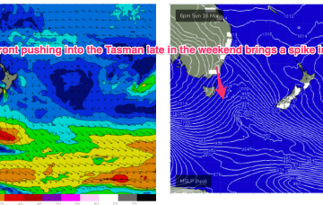
The front responsible for today’s large southerly swell has already exited our swell window, so we’re looking at a steady drop in size from Tuesday onwards.
/reports/forecaster-notes/sydney-hunter-illawarra/2025/03/14/easing-swells-weekend-spike-in-s-swell
freeride76
Friday, 14 March 2025
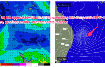
SW gales push through Bass Strait and off the Far South Coast Sun night and into Mon with the bulk of the frontal winds likely to extend up to Sydney in the hours before dawn.
/reports/forecaster-notes/sydney-hunter-illawarra/2025/03/11/small-weak-blend-continues-and-over-the
freeride76
Wednesday, 12 March 2025
N’ly winds will increase over the weekend as a more significant trough and frontal system pushes into the Tasman next week, generating swells from the southern quadrant.

/reports/forecaster-notes/sydney-hunter-illawarra/2025/03/10/small-mixed-bag-week-action-the-s-medium
freeride76
Monday, 10 March 2025
The whole synoptic pattern on the East Coast in the wake of Alfred is a moist onshore flow which looks to persist through into the mid week. A weak front races across the lower Tasman before reinforcing high pressure slips into the Tasman to reset the flow, albeit at a weaker level. Not a great deal of swell generated by any feature this week.
/reports/forecaster-notes/sydney-hunter-illawarra/2025/03/07/slowly-easing-surf-tc-alfred-onshore
freeride76
Friday, 7 March 2025
Depending on the movement of Ex TC Alfred we’re highly likely at this stage to see an increased NE-E/NE flow along the NSW Coast early next week as the remnants of the system drift down the Northern Tablelands.

/reports/forecaster-notes/sydney-hunter-illawarra/2025/03/04/plenty-size-the-wind-field-associated-tc
freeride76
Wednesday, 5 March 2025
Massive surf from the Moreton Bay Islands across the Gold Coast and down through Northern NSW will continue until the cyclone crossing, with much smaller surf on the Sunshine Coast and into temperate NSW. It’s been an epic event with a gnarly exclamation point expected as Alfred makes landfall.
/reports/forecaster-notes/sydney-hunter-illawarra/2025/03/02/plenty-swell-ahead-large-high-cradles-tc
freeride76
Monday, 3 March 2025
Alfred is expected to move SE today, generating mod to large swells down the NSW coast (it’s already solid in the sub-tropics!). Alfred takes a westwards turn thorough Tues into Wed and there’s now model consensus we’ll see a coastal crossing in SEQLD or far NENSW Thurs or Fri.