The curious case of Tropical Cyclone Winston

As a surfer growing up in the 80s I often heard stories about the Gold Coast's famous 23 day swell of 1975. It was lore up there in Queensland, a tale that kept getting retold, yet as I got older I began to suspect that maybe it had a touch of the porkies about it. I mean, 23 days from one single swell source?
Most tropical cyclones, at least the ones that form in the southern Coral Sea and provide the east coast with swell, are flash in the pan events. If there's no other atmospheric interference a cyclone will head south and then very quickly be absorbed into the mid-latitude westerly airflow and begin to decay. The opportunity to provide swell, therefore, is minimal.
Which is why Tropical Cyclone Winston is a curious fish. Formed on February 11th, TC Winston has been circling around the far reaches of Queensland and northern NSW's swell window for a fortnight, and except for a short pause behind New Caledonia it's provided waves the whole time.
Fourteen days of swell with the likelihood of many more to come? All of a sudden that 23 days swell doesn't sound so ludicrous...
To get a bit of context I spoke to Professor Ian Goodwin about the curious case of Cyclone Winston.
For the first week of its life Winston behaved normally. It formed near Vanuatu and moved south into our swell window, the first lines making landfall on the 15th of February. "The really interesting thing," says Ian, "is that Winston was taking the track of a normal cyclone. We'd normally expect it to keep heading south and disspate in the mid-latitude westerlies, except it got captured by an extremely strong high pressure system."
It's the influence of this high pressure system that's caused Winston to behave in an unusual manner. The high was centred over New Zealand with strong easterly winds blowing across the top of it.
These winds are a "classical easterly dip" says Ian. "Think about the formation of an easterly trough low, or an ECL [East Coast Low], they form in that dip, except they often occur in the middle of the Tasman Sea. However, this time a sub-tropical high pressure system has an easterly dip." The result is that Winston was captured just before it was lost to the mid-latutide westerlies. It then got a second wind, so to speak.
"The fuel for this one is not coming out of the tropics, it's coming out of the sub-tropics. It's a weird hybrid of a tropical and sub-tropical storm system."
Caught by the strong high pressure system, Ian says the "moist easterly airstream continued to fuel it, and because the high pressure system wasn't going anywhere the only exit for Winston was a path back toward Australia." Although cyclones are notoriously unpredictable that's the exact opposite of what you'd expect to happen.
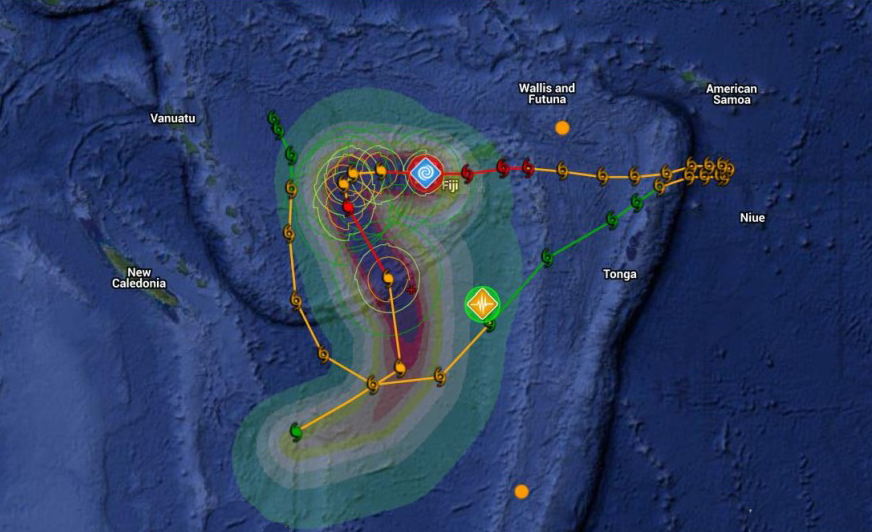
The path of Winston, first moving south, then quickly north-east, before being captured and sent back west
"It's what we call a retrograde system," says Ian of the east-to-west movement of Winston, "and this is retrograding a long way." As Winston retrogrades a 'captured fetch' scenario develops whereby the storm moves in the same direction as the wind creating a compounding effect with swell production.
Interestingly, as big wave surfers in the North Pacific bow down at the feet of El Nino, Ian believes it's the little boy's sister who we have to thank.
"Yeah, La Nina is the wildcard. A strong sub-tropical easterly," such as what captured Winston and caused it to retrograde, "is a signature of La Nina."
"Everyone was waiting for this big El Nino signal which really wasn't there," says Ian "And it's slipping back into this persistent La Nina mode and that's what's caught a lot of people off guard."
"The Pacific is slipping back into La Nina because of the Decadal La Nina pattern. This system is potentially a precursor of moving back into La Nina."
When we spoke, Ian was clearly excited by the nature of Winston though not necessarily surprised. "Yeah, these kind of systems do happen" said Ian when I asked if it was an anomaly. "In fact, they happened more when we were last locked into a La Nina background phase which was the 60s through to early 70s."
Maybe the old boys were telling the truth all along?
STOP PRESS: Phil Jarratt, a man whose memory should never be doubted, said his "recollection of the 23-day swell is that it was back to back TCs, but they overlapped and there was no day off. Kirra was off and on a bit but Burleigh just pumped."
Comments
It's the NE movement that has got me asking the questions. It's unusual for a TC to take the graveyard direction (SE) and then change to the NE. What caused this sudden change when normally the TC would have whisked off to the SE. I can't see how the high pressure system caused it to go NE, unless that's when the high slid underneath and parked on the SE flank?
Also, I always thought it was the upper winds that steered TC's. The above article implies winston was steered by the MSLP high?? Is this because the upper winds were not existent at the time and hence steering was then only dictated by the MSLP?
the MSLP's are often dictated by the uppers . So both the surface blocking high and the Cyclone/ Hybrid re transitioning to warm core were influenced by the uppers . In this case the ITCZ from the already peaked El Nino is still in the Western Hemisphere . This general circulation drew it NE as a combination of attraction and a minor repass of the MJO in that region . The surface high had more influence on Winston as a Hybrid with less warm core features the transition sees it more influenced than normal by the surface . And it this case with less upper steerage it got shunted NE . To rebuild and then spin back up again . If your in the Sthn tropics and a Cyclone is about you are best sailing NE , as this is the less likely direction of travel but not always certain .
"Everyone was waiting for this big El Nino signal which really wasn't there," says Ian "And it's slipping back into this persistent La Nina mode and that's what's caught a lot of people off guard."
Beg yours Ian?
Maybe look at the Australian rainfall anomalies and NAM before making that call.
Average rainfall for Ballina for Feb is around 200mm. Right now, three days before the end of the month we are at 47mm and it looks like Bourke.
South Pacific cyclones, of which Winston is one, as opposed to Coral Sea cyclones are a feature of El Nino's.
Please explain, because all the parameters I'm looking at suggest a classic and strong El Nino signal at work.
From Ian: "What I was saying is that the Pacific is slipping back into La Nina because of the Decadal La Nina pattern, NOT that we have moved into La Nina at present. This system is potentially a precursor of moving back into La Nina."
And: "The BOM state on their website that the trades are the strongest in nearly 2 years which occurred during strong La Nina events. The official line is that El Nino is weakening."
FR, I bow to your in-depth knowledge of atmospheric science, but don't miss the trees for the forest.
As a heavy El nino summer, there has been more widespread and heavy rain over the east coast and inland than any I can recall. A very untypical el nino event in that respect.
The monthly rainfall for Ballina in February is hardly something to hang your hat on. Except for the last two weeks in Sydney, the grass hasn't been watered once, and couldn't have soaked up any more. That covers December through to early Feb, and it wasn't just Sydney.
I take your point BF but take a look at rainfall deciles for the whole of Aus. And although Feb figures haven't been released yet ill bet sheepdogs sheep station they show a full blown El Niño signal.
Whether this system is a sign and symptom of a decaying El Niño , let alone a developing La Niña is yet to be seen. This trades are subtropical not tropical in nature.
23 days? Pffft!
In Queensland memories, it was the 28 day swell. Burleigh Brewing put out their 28 Pale Ale in honour of the 1975 28 day swell. I don't think you can get more authoritative than that.
Burleigh Brewing had a good article about it. Their website is under redevelopment, but I found the page in archive. Burleigh Brewing said the article was sourced from Pacific Longboarder.
It's good reading.
https://web.archive.org/web/20140125235826/http://burleighbrewing.com.au...
i wouldn't take anything that was said to have happened in the 70's as gospel .... many were too imbibed to notice what was happening out in the mid pacific . And satellites were a dream .
As for the ElNino - La Nina comments . think of it more as the condition builds thats when the atmospheric ( not necessarily combined with precip's but sometimes ) signatures are at their strongest . An ElNino stretches out the rubber band so to speak , the La Nina is when it snaps back . So hence in Aust anyway , droughts are prolonged and floods are fleeting . The decadel influence is often mostly caused by the PDO which is long term cycles of the Nth Pacific . The Sth Pacific cyclical influences are far less prolonged as the Southern Ocean tends to leak and replace many shorter patterns . The Nth Pacific apart the ITF , and far less extent Arctic injection , is close to a closed system . Hence it tends to see far longer trends .
All i'm thinking about is how uncrowded it would have been back then...
How days would have gone on for longer...
How worries would have been lesser...
And how stories became grander...
Even if this swell is going to be off the charts... the romance of it all certainly won't be there.
But hey... i'm still frothin!
Well, I didn't have the chance to surf the GC in 75, but I was there over Christmas / New Year in 78 and I wouldn't call it uncrowded. I can remember a great surf at Burleigh on Boxing Day, but there was a crowd. It wasn't as crowded as what I've seen in recent photos but there was still plenty of hassling for waves. You're right about stories becoming grander. Memories fade and the good bits are amplified. I've returned to surfing after a long break, and I'm finding there are spots that are less crowded than they were in the 70s and 80s. I'm not referring to the GC or far north coast. If the recent photos are typical then those places are reaching, or have reached, their saturation point.
Totally hitting saturation point! And where are these mystical spots you speak off?
In terms of memories of swell events, do you think it has something to do with surfing becoming more mainstream that these legendary swell events aren't becoming legend anymore? Now I'm an early Gen Y .. just.. and thinking of the 60's and 70's, I envisage grainy overexposed memories of better times, as if the memories of those times is what was captured on the surf films. As each decade comes, the picture becomes clearer yet more and more cluttered as more and more memories are recorded. Now we have images of quality waves going off all around the world, all at the same time, in a clean-up-set of digitised memories, with images from Waimea to the GC all going off, all at the same time like its becoming a normal occurrence. There's such an whitewash of memory creating swell events all contributing to our bandwidth, that now a single event is just not as potent as it once would have been.
Now I'm not sure why I'm waxing nostalgic... it's 930pm and I have a sickness I need to conjure overnight so I can pull a very rare sickie tomorrow! Hope you get some! I think I'm heading north. Gotta be a bit better than the GC crowd wise... surely.
Ah, I'll have to take the Swellnet line and not disclose these spots, but they're certainly not mysterious or secretive. They were saturated in the 70s and 80s but perhaps the surfing population has spread a bit. Or the area has gentrified; the local high school has less kids than it did 40 years ago. Your analogy of old film and ageing memories is a good one. And I think your theory about over-exposure of big swell events is spot on. It all becomes nothing unusual after a while.
Tripper, I'm frothing too Bro !! How is this all going to effect the Indian Ocean swells leading into the tradational Indo season. Donweather, we're heading down to the Maldive southern outer atolls in late Sep and wondering what to expect based on whats been happening in the Pacific so far this year?
As in Beacons region? Late Sept can still be quite windy down there I thought? No shortage of swell mind you!!! Just expect some winds early on in your trip more likely. Oct/Nov better best down south I thought.
I was in that region in early Mar of '14, it blew it's ring off...unseasonal they said. Moral of the story, don't trust the weatherman.
The 23 day swell must've had some trade swell in the mix...
yep
I'd be bullshitting to say I remember it clearly..... I don't..... I just remember there was always waves as a kid.... Perhaps this swell is what paints the false picture....
January 75.... Cyclone Flora, Gloria, and Val maybe??
Cant see it being march - Cyclone Alison and low "197529".......
BTW, 75 had some crazy movements by cyclones and tropical lows..... Cyclone Val did a dance around Fiji.... "197529" did a complete loop.....
Cyclone Val;
Fascinating analysis, thank you. My thoughts are with my gentle friends in Fiji, very sad situation. Is the good professor the Ian Goodwin who went over the falls on our Nymboida River trip in around 1982 or 83? If so say a big g'day to him from Holly. Thx.
Of course holly, over the falls on a nymboida waterfall
Thanks Ian for your knowledge.
Similar to" BatFink's",... But it sounds like you know what seedlings are going to grow in the forest, likewise with Southey's explanation;)
Cheers