Largest swell of the Indo season due this week

It's been a great early season across Indonesia with plenty of swells to keep the punters happy. However, as we move into the end of this week things will become much more serious.
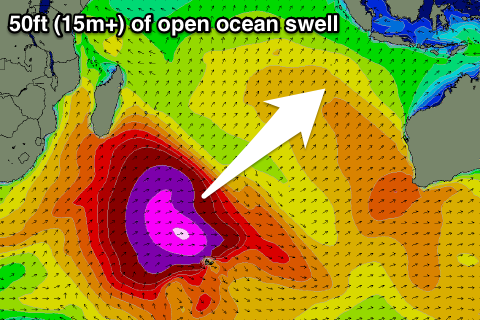
As mentioned in last Thursday's Bali forecast notes, the largest swell so far this year is currently bearing down on the Indonesian Archipelago and beyond. The Maldives to the west and Timor to the east will also receive the brunt of this swell.
The weather system responsible for this swell started its life under South Africa during the middle of last week and after providing pumping waves in J-Bay, it morphed into a monstrous storm in the Souther Indian Ocean.
A series of strong frontal systems have projected 35-50kt+ winds towards Indonesia and Australia, setting in motion a large open ocean swell to 50 feet.
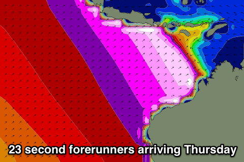
The sheer magnitude of the frontal progression has also resulted in extremely large swell periods upwards of 23 seconds at the head of the swell.
The Mentawai region should see the swell arriving through Thursday and kicking to a very large 12-15ft at exposed spots later in the day ahead of a peak overnight and drop from 12ft+ Friday.
The swell will take a little longer to arrive in Bali, kicking later Thursday and peaking Friday to 10-12ft+ across exposed breaks.
The same swell is due across Western Australia late Wednesday and Thursday while also tracking across to South Oz and Victoria for a peak on Friday (albeit hidden under a better medium-range W/SW groundswell).
Keep an eye out on the site for pictures and videos from this oversized swell event and in the meantime keep abreast of the current forecasts for Bali and the Mentawai Islands below.
16 Day Bali Forecast Graph and Notes
16 Day Mentawai Forecast Graph and Notes
Comments
Hey craig , today the w.a. Swell bouys showed very little of this expected swell & period . What do u think is going to happen ? Do u think it will be far bigger for sa-tas ?
Hi Camel, it was only expected to pulse later today, and the buoy data is still old, updated at 4:42pm.
I wouldn't worry about it not showing before dark, should be well and truly in tomorrow.
You wont really be able to distinguish the swell in SA and Tas as the system currently south of the Bight and the following one through the Bight will generate swell larger than the long-range groundswell from the Indian Ocean.
Just as I posted Rottnest picked up the 20s periods..
Thanks craig for giving us hope but the BW & W guru etc had the period @ 20 from this morn . And big so thats why i said that . I hope your right
Craig funny thing is i just logged onto each wa bouy but the period is small
Same here Camel, I just logged back to Rottnest and it was smaller again.
But.. then I hard refreshed (command + R on Mac / ctrl + F5 in windows) and it came up with the 20s stuff.
Jurien Bay is showing it as well..
Did it go up n down within ten mins ? Funny that but i did check swellnetd forcast & its much more realistic compared to the other crews over rating of the sze.
Ok craig thank you . Will try on my droid fone
The wa west coast has recieved good period and mid size
Yeah nothing outrageous but the storm was aimed more towards Indonesia and Sumatra more than anything.
Roger that craig
Hey craig the sorrel bouy is big but not much along esp alb
CDC and Sorell are picking up a totally new swell, much larger than the long-range groundswell.
I didn't expected any major size from the Indo swell passing under WA and to SA.
The CDC and Sorell swell are from a very strong frontal system pushing in from under WA, south of the Bight and towards Tassie and will provide some serious waves at you know where tomorrow.
Here's the storm in these two images below..
already got it craig & tmoro could be too windy. There was strange forecasts with sites sayin 20 sec this arvo but you knew true . Partly mixed swell / captured fetch situation hey craig .? Only 15-16 max
Sorry didn't mean your region, this morning down Tassie way should be huge and pumping. Glad you scored that window, was lining up real nice through the week!
The forecast would of been mixed because the storm shown above (moving under Aus) produced a much larger swell compared to the easing long-range 20s energy from the Indian Ocean.
Captured fetch usually refers to a swell being re invigorated by the same system that produced the primary swell train .
So in this case and many times this swell is just being generated quicker / easier and will gather strength better with " an existing sea state in place " especially when the secondary fetch is aligned in a very similar direction as the initial primary swell .
Northerly winds now Camel at 10 knots should be clean, hope it doesn't get too strong. You may get a window at dawn. Good luck!!!
Hey mick way too windy for spot xs but could be a spot under cliff shelter . But the jobs on to kite surf this morn an outer peak
Winds are howling 20kn at dawn here. Soon i will hear from mate in bali for an update for this thread oh also the norwest report
Yeah keep us updated.
From first hand experience , that swell just went thru southern ocean & it started being large off south africa not just a new swell . It was captured fetch & it was a mixed period at times . Dont try tell me your more on to it . Unless you was out amongst it not at work .
Your right craig but its like the chicken & the egg with this situation
Caml , I agree with the concept , it's just that theoretically only cut off lows or cyclones really create a true captured fetch . ( one low or an aligned fetch continues to act upon the swell IT initially created ). An AFL player running with the ball if you like ...
Generally speaking the southern ocean has multiple lows / fronts / fetches / systems acting upon various swell trains . It's the ease of a fetch to re invigorate an existing agitated sea state that gives a similar appearance of " captured fetch " . I would go as far as to say that any fetch within 15 degrees of a same direction of a primary or pre existing swell will given enough distance , join the others rhythm strength / power . None of this is , text book ... This could be put as a whole midfield " sharing " the ball from one end of the field to the other ..
Sorry for the shit euphemisms ....
Fuck it's windy here ...
Camel I'm in Kommetjie, while they had a big swell here on 23rd May which had big westerly flank, talking to the local guys seems the few last storms are getting far more powerful after passing South Africa. Even today the swell is 4m but waves are bigger on the East Coast of South Africa. I'm not sure if Craig has got some reasons (ie LWT), but that storm for Indo mid May had a similar grading it went all supernova in the middle of the Indian Ocean with a massive fetch. Did you get any NW, indo reports yet?
Mick ,
I posted this on Monday , in the " Bali forecast Notes " ( Bali 3 swells comments ) ...
" Don't forget that there has been an abundance of warmer water off the Eastern Coast of Africa out as far as RI , and now that the Southern Storm track has kicked in ( whether through the SAM's influence in more nth / sth aligned upper jetstreams or just lower central presures in nodal LWT activity ) . The two have seen systems really ramp up or hold strength even after being bunched up after passing Sth of Africa . Alot of the time after a system moves into the Indian it will expand and lose intencity . If this warmer water isn't present then the systems tend to weaken a little on entering the Indian area of the Southern Ocean , then bomb further east after a secondary interaction , be it from Uppers or sea surface / currents , later or not at all ... Generally surface instability is invigorated by poleward troughs or cutoff lows moving back down poleward . But in this last few weeks case , the fronts have created the instability over warmer sea surface conditions . Leading to systems bombing to aim more Equatorial in movement ( push up and expand whilst maintaining central intencity or even bombing ) like the last one . ? "
Craig looked into the SAM , and it didn't look like a connection , so I would hazard a guess that the SST's have been influencing firstly the LWT , the upper mid jet stream , and for a longer bow , even the MJO and trigger of a possible Negative IOD all had an impact . If I'm right then I would expect to not last all season ... Perhaps maybe one more similar setup in another few weeks time .... Time will tell ..
Thanks southy for the info, sorry often miss stuff not being able to read all the forums. Pretty fascinating stuff what you have written. Kind of goes over my head to be honest, but interested in the information that you pass on. Water is unseasonably warm here in Cape Town. Still haven't got too much info on this swell, the obvious spots would have been mental like Nias. It would have been nice to hunt out a few spots that would have been on with no one around though. Wonder if Camel has anything.
So does anyone have any reports, pics videos etc of how this swell faired in Indo. I'm hearing it came in under expectations again?
Slim from Baliwaves has posted some pics of the Padang trials a day or two solid but nothing huge.
some other reports indicate that most of the size hit g land and the ments.
kandui face book page - large swell but devil winds [north] and swell size came in below expectations ?
Donald , is there anywhere to check swell heights/history from the Cocos/keeling islands ?
U can see a lot of the sizes at jurien bouy and rottnest although not indo but yes very underwhelming . If u checked the bouys every minute for the last week like i did ( all bouys jur- sorrel & the peak periods on wa bouys) u see it wasnt so heft but all my contacts at nw wa are still out of range which probably means good surf .
Ten ft ulu & about same size as w.a. Mate reckons .
Mates in Simelue said they didn't get the 'big' swell. Have just reported fun waves over the last few days