OK waves through the week, fun across the South West on the weekend

Western Australia Surf Forecast by Craig Brokensha (issued Monday 25th September)
Best Days: Thursday morning, protected spots in the South West Friday morning, Saturday and Sunday mornings
Recap
Large stormy waves continued Saturday but with a slow easing in swell while Sunday saw offshore winds develop across all locations as a strong low formed off our coast with a bit more size than expected.
Margs hung in at 6ft+ while Mandurah saw 3-4ft sets and 2-3ft around Perth.
This morning we're back to 3-4ft waves across the South West with a SE breeze and 2-3ft waves around Mandurah with 1-2ft surf in Perth.
This week and weekend (Sep 26 – Oct 1)
Our models are showing an increase in size through tomorrow, but this looks to be a mistake, with local S/SE windswell from the weakening mid-latitude low moving across us mixing in with small amounts of background SW groundswell.
Margs should hang around 3-4ft with the surf easing to the north back to 1-2ft, smaller into the afternoon. Fresh and gusty S/SE tending S/SW winds will create less than ideal conditions with lingering onshore W/SW winds expected into Wednesday as some new SW energy fills in. Perth and Mandurah should see clean conditions early with a variable tending offshore wind.
This new SW groundswell has been generated by a strong polar front in the Heard Island region over the weekend.
No major size is expected but we should see Margs building to 4-6ft into the afternoon, easing from a similar size Thursday with 1-2ft sets further north.
 Another cold front approaching from the south-west is expected to develop into a mid-latitude low off our coast on Wednesday evening resulting in winds swinging back offshore for Thursday morning.
Some new S/SW swell is due off this front for Friday, coming in around 4-5ft across the South West and 1-1.5ft further north, but a larger S/SW groundswell for Saturday is the one worth noting.
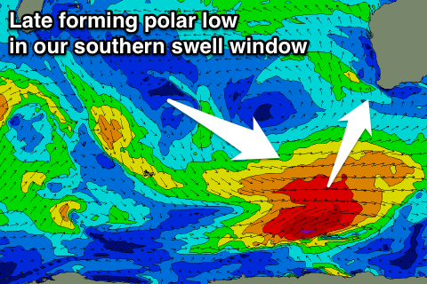
A vigorous polar low will form late in our swell window on Wednesday evening/Thursday generating a fetch of severe-gale W/SW winds below us.
A moderate to large sized S/SW groundswell should be seen across the South West on Saturday, peaking into the afternoon to 6ft on the sets, while Perth and Mandurah aren't due to see much size at all.
Conditions are looking great for this swell with a straight E/SE offshore wind tending S/SE into the afternoon, more E/NE with S/SW sea breezes Sunday.
Longer term we've got a couple of sources of new swell, one being from secondary storm activity on the back of the intense polar low, and another being W/SW swell from another mid-latitude low stalling to our west. More on this Wednesday though.
Comments
Great White
3.5m length
DorsalHQ
Distance from Shore
50m
Type of encounter
Sighting from water
Location
Near North Point
Weather Condition
N/A
@SLSWA: Public report 3.5m white shark sighted 18:46hrs 25/09, North Point Beach, Gracetown 50m offshore , acted aggressively towards surfer..