East winds and south swells

Victorian Forecast by Craig Brokensha (issued Monday May 6th)
Best Days: Beaches to the east all period
Features of the Forecast (tl;dr)
- Inconsistent W/SW groundswell for this afternoon, easing tomorrow with E/NE tending variable winds
- Easing swell Wed AM with E/NE tending N/NE then variable winds
- Strong pulse of S/SW groundswell later Wed and Thu AM with E/NE tending S/SE winds
- Smaller Fri AM ahead of a secondary strong pulse of S/SW groundswell into the PM, easing Sat PM
- Mod-fresh E winds Fri, tending SE, with fresh E-E/SE winds all day Sat
- Small SE windswell in the mix Fri/Sat/Sun
- Easing swell Sun with E-E/NE tending variable winds
- Smaller Mon with NE winds
Recap
We saw easing swell with average conditions across the Surf Coast all weekend, best to the east and biggest Saturday morning before becoming small yesterday morning.
Today, some new, inconsistent swell is offering 3-4ft sets to the east with bumpy 2ft sets to the west. We should see a touch better W/SW groundswell energy building into this afternoon but with sea breezes.

Fun sized sets this AM
This week and weekend (Apr 7 - 12)
East, east, east.
High, high, high.
In short that’s the summary for the coming week or so with persistent high pressure due to dominate our local weather and surf outlook.
Various evolutions of high pressure are due to sit just west of us this week before slowly moving east, under us on the weekend.
With this we’ll rely on long-range groundswell energy, as is the case this afternoon and tomorrow morning, with some better, S/SW groundswell energy due from mid-late week and on the weekend, emanating off strong polar fronts skirting around the southern flank of the highs.
Looking at the pulse this afternoon and tomorrow morning, this was generated by a strong but distant polar low that formed east of the Heard Island last week, and inconsistent 2-3ft sets should be seen on the Surf Coast and 4ft+ waves to the east, easing into tomorrow afternoon.
Conditions will be great for the beaches tomorrow with an E/NE offshore, tending variable into the afternoon, and E/NE tending N/NE on Wednesday as the swell fades (variable into the afternoon).
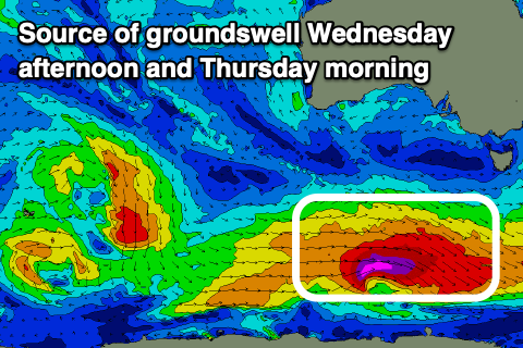
Later in the day Wednesday, and Thursday morning, a good pulse of new S/SW groundswell is due, generated by one of the above mentioned frontal systems skirting around the base of the high. This strengthening system will be strongest once under Tasmania, but the early developments should produce a good kick in size later Wednesday to 3-4ft on the Surf Coast, 4-6ft to the east, easing from a similar size Thursday morning.
With this, we’re set to see winds remain favourable for the beaches, and E/NE through the morning ahead of S/SE sea breezes.
Our next pulse of groundswell is due into Friday afternoon and Saturday morning, produced by a similar though slightly more distant polar storm, with fetches of severe-gale to storm-force winds due. The size looks a touch stronger and more to 3-5ft on the Surf Coast and 5-6ft to the east both later Friday and Saturday morning as winds persist from the E Friday morning and E-E/SE all of Saturday.

These winds will also kick up some localised SE windswell for the Surf Coast from Friday through Sunday, easing into early next week.
Winds on Sunday look to remain favourable and from the E-E/NE, variable into the afternoon, with a shift in winds more to the north-eastern quadrant next week thanks to the high moving east under us.
Swell wise, there’s nothing major but conditions will remain favourable for the exposed beaches, with an increase in poor windswell likely later next week along with southerly winds. More on this Wednesday.
Comments
Fark! The Surfcoast has dysentery with that forecast. Again!
May- WTF?
sounds too big for me on the mp
4.5 to 7 ft, much prefer 2.5 to 4.4 ft
Hey FR, what creates those banks at Woolamai and Magiclands compared to the Mornington Peninsula... always seems so defined with a smallish swell and offshore, the banks there always seem to be in the same place without any shift? Looks really fun and long rides.
hey CB left of field question here....when this AI super computer completes mapping earth 2 and reading weather/forcasting. when completed it will punch out forcasts 3000 times quicker than currently, what does that mean for us #1 quicker updates or #2 more accurite forcasts. or #3 all of the above....