Large swell from a 'bombing' low goes to waste

Victorian Surf Forecast by Craig Brokensha (issued Monday 2nd October)
Best Days: Today on the beaches, tomorrow for the desperate Surf Coast
Features of the Forecast (tl;dr)
- Weak, easing swell today as winds shift E/NE-NE
- Small, inconsistent, mid-period W/SW swell tomorrow with W/NW winds, shifting S/SW mid-PM and strengthening
- Strengthening S/SE winds Wed
- Moderate sized, inconsistent W/SW groundswell arriving late Wed, peaking Thu with strong S/SW winds
- Moderate sized S windswell Thu
- Large SW groundswell building Fri, peaking into the late PM with strong but slowly easing S/SW winds
- Large easing S/SW groundswell Sat with moderate S/SE winds, strengthening from the S during the day
- Easing swell Sun with moderate S/SE winds
Recap
Friday's good mix of swells started to ease back through Saturday under N'ly winds with both regions offering clean, fun waves. The Surf Coast backed off from the 3ft range with 4-6ft sets to the east, smaller yesterday but nice and clean through the morning.
A strong change moved through yesterday and a mix of weak swells have come in a little stronger than expected with 2-3ft sets on the Surf Coast and 4ft waves to the east. N/NE winds are favouring the beaches and will hold from the E/NE-NE into the afternoon as the size drops away slightly.
This week and weekend (Oct 3 - 8)
The current swell generated by the frontal system moving through yesterday should ease this afternoon, replaced by some new, longer-range W/SW swell energy tomorrow.
It's only expected to be small and to 2ft+ on the Surf Coast magnets and 4ft to the east, generated by a weak front ahead of a much stronger frontal progression that developed south-west of Western Australia.
Winds will be favourable for the Surf Coast tomorrow morning and W/NW ahead of a mid-afternoon S/SW change as a trough pushes through.
The stronger frontal progression has been generating a slow moving fetch of gales with bursts of severe-gales on the weekend. A moderate sized, inconsistent W/SW groundswell is due to arrive late Wednesday from this source, peaking Thursday morning to 4ft on the Surf Coast and 6ft to the east.
The only issue are the local winds, with the remnants of the swell generating system due to bring tomorrow afternoon's change, lingering Wednesday to our east and deepening into a low. This will see strengthening S/SE winds on Wednesday creating deteriorating conditions with a building windswell that looks to become bigger Thursday morning.
A junky 4ft of windswell mixed in with the groundswell is due Thursday across the Surf Coast but with strong S/SW winds and nowhere to recommend.
The low will start to move off to the east Friday as a strong but stalling high nudges in from the west, allowing winds to slowly ease but remain from the onshore the S/SW (strong in the morning).
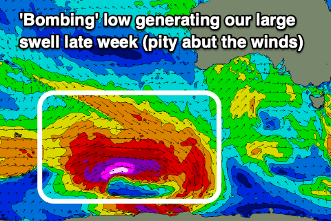
Our, large SW groundswell that's due to fill in Friday is still on track, with it generated by a 'bombing' polar low that will form around the Heard Island region today.
The position of this low is much better compared to the frontal progression generating Thursday's W/SW groundswell, with a polar fetch of pre-frontal gales due to give way to much stronger severe-gale to storm-force W'ly winds, south-southwest of Western Australia tomorrow.
The low will weaken while continuing slowly east during this week resulting in a large, long-period SW tending S/SW groundswell that should arrive Friday morning and build rapidly to a peak into the late afternoon. Building surf to 6-8ft is due on the Surf Coast magnets by dark, 8-10ft to the east, easing back from 6ft and 8ft respectively Saturday morning.

With the high strengthening and stalling to our west on the weekend, winds will remain moderate from the S/SE Saturday, strengthening from the S'th through the day with lighter SE winds on Sunday.
So all in all it's looking to a bit of a waste of a swell event.
The high will start to slowly move east through next week bringing a slow improvement in winds that will shift E/SE Monday week and more offshore Tuesday morning but with smaller, easing surf.
Longer term there's nothing too significant on the cards so all in all it's a tricky period to work. Make the most of the beaches today!
Comments
That High looks to be stalling so bad we'll need to call RACV to get it going again.
Haha.
Need a rolling hill start eh?
I think it actually goes backwards over the weekend,
title reads like another day ending in Y for us in WA
And starts with A?
what day starts with an A craig? my monke brain does not compute, all I'm thinking about is the wind finally backing off tomorrow
Aghh haha misread. Thought you were talking a location, not every day ;p
hahah righto
NE swell small
N blustery
NW swell rising, coast blown out
SW swell peaks, onshore corners
S swell fades, onshore corners
SE offshore, smaller
E, offshore, smaller
but when the stars align it's epic...
the SW WA cycle of insanity
Some good lightning through the night
Yeah hopefully it'll go over and put out some of those Gippsland fires
Yep, plenty inbound thankfully. The fire up at Evans Head is a worry with the coming days of strengthening winds.
You guys being further north, do you see any rain from the fronts going over here or is it rain from the north?
We sometimes get pre-frontal stuff ahead of the fronts moving in across Victoria, but when the zonal stuff really kicks in we get rain shadowed by the Great Dividing Range. Crisp, clear blue skies for day on end.
Hey Craig, Torquay beach webcam replay, 7:30am, 29:40 - wtf is that just under the horizon going from right to left at speed? It appears to be either the shadow of an aircraft, or something with no fin moving very fast just under the surface. Nessie?
Agh, haha flock of birds!
Any chance of an Easterly groundswell to light up the novelty breaks in Vicco?
Looks a bit too north. There'll likely be some small E/NE groundswell wrapping in Thursday though across locations in eastern Bass Strait. With some building mid-period energy tomorrow afternoon.