Mixed forecast though with no lack of size

Victoria Forecast by Craig Brokensha (issued Monday 18th May)
Best Days: Selected spots tomorrow, Surf Coast Wednesday, Friday
Recap
Small though fun and clean waves across both coasts on Saturday with surf around 2ft on the Surf Coast, 3ft to the east.
Yesterday our good mix of W/SW and SW groundswell filled in with a bit more size than expected across both coasts. 3-4ft waves were seen on the Surf Coast, 5-6ft+ to the east with good conditions all day across both regions.
The swell has eased a touch back into this morning to 4-6ft on the Mornington Peninsula and 3-4ft on the Surf Coast with local offshore winds and great conditions again. A new W/SW groundswell is due into this afternoon and this was expected to offer similar size waves to this morning, so we'll likely just see the swell remain steady with favourable winds for the beaches.
This week and weekend (May 19 - 24)
 This afternoon's increase in W/SW groundswell should peak tomorrow morning with the surf due to persist around 3-4ft on the Surf Coast (odd bigger one on the magnets) and 5-6ft+ on the Mornington Peninsula with stronger offshore N/NE winds. This will limit surfing options with the larger swell on the exposed beaches and bumpy conditions on the Surf Coast reefs.
The swell should start to ease into the afternoon and drop slowly through Wednesday as winds shift to the W/NW and then back to the NW through the day with a passing front.
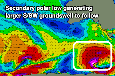
This front will be attached to a significant polar low forming south-west of Tassie on Wednesday, with an initial projection of gale to severe-gale SW winds through our south-western swell window Tuesday evening to then be followed by a stalling fetch of severe-gale to near storm-force W/SW winds in our southern swell window.
The initial burst should generate an initial building SW swell for Thursday ahead of a larger S/SW groundswell Friday.
 Unfortunately though in the wake of Wednesday's front, winds look poor as a high moves in bringing fresh S/SW winds as the first pulse of swell builds to 4ft on the Surf Coast and 6ft+ to the east into the afternoon.
A slight reprieve from the onshores is due Friday as winds shift back to the W/NW, giving into afternoon sea breezes with the large new S/SW groundswell. Size wise the Surf Coast should see sets pushing to 5-6ft through the day (possibly a touch undersized at dawn), 8ft on the sets to the east.
The swell is expected to peak overnight and then ease back through the weekend but with poor and strong S'ly winds Saturday, fresh and easing from the S'th on Sunday.
It looks like winds will linger onshore into early next week as the high stalls to our west and a broad low forms off the NSW South Coast. Some new inconsistent W/SW groundswell is likely though as winds improve from Tuesday but we'll have a closer look at this on Wednesday.
Comments
Aghh, with Sunday/Monday's swell punching a little above their weight I ignored rule number 1 in forecasting, and that is, treat every swell individually and don't overreact with the next swell.
I didn't follow this and upped today's new W/SW swell a little and it's gone the other way and come in a touch under. At least it's not too big for the MP beaches...
tisk tisk in the naughty corner with ya......
Lucky it's been a great run.
My word it has
The swell has backed off at Westernport today. Friday looks better to get wet. Thanks for the updates.