Ain't winter grand in Southern NSW?

Sydney, Hunter and Illawarra Surf Forecast by Ben Matson (issued Monday 19th June)
Best Days: Great waves most days, especially Wednesday with light winds and a peak in E'ly swell. New southerly groundswells for the weekend, largest Sunday.
Recap: Easing S/SE swells over the weekend produced fun waves across Sydney beaches on Saturday. Smaller surf prevailed into Sunday with winds picking up from the south. Today we’ve seen a building SE swell that’s around the 3ft mark and winds have been mainly fresh southerly in most regions though the Northern Beaches saw W/SW breezes until late morning.
This week (Jun 20 - 23)
We’ve got some really good waves ahead this week.
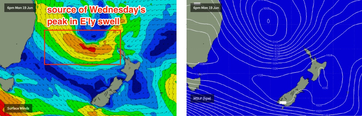
A broad Tasman Low is currently aimed mainly towards Northern NSW and SE Qld, but a developing easterly fetch across its southern flank will generate a strong E’ly swell for our region over the coming days.
The models have slightly changed the configuration of this fetch, and pushed it a little more to the east, which has marginally tempered wave height expectations since Friday's outlook and also slightly delayed the arrival the bulk swell energy.
Tuesday will see a fresh round of E’ly swell fill into the mix, building to 3-5ft across most open beaches. Winds are expected to remain some form of moderate S’ly breeze but we should see isolated pockets of light W/SW winds in the morning.
Wednesday morning will see a continuation of this size range ahead of a second, larger E’ly swell arriving from mid-morning and peaking into the afternoon. This should nudge the 5-6ft range at exposed beaches that reliably focus easterly groundswells. I wouldn't be surprised if we saw a few bigger bombs at offshore bombies too. I'm not sure why our model isn't picking up this swell very well, as it's a broad system with a relatively uniform, slow moving fetch. Neverthess we may see this nudged up in the height graphs over the next day or so (it currently has Wed PM maxing out at 4ft, via 1.8m @ 10.1 seconds - in reality the swell periods should be higher than this).
Even better - winds should become light and variable across most beaches on Wednesday as the pressure gradient weakens across the coastal margin. So conditions should be great everywhere.
Surf size will then slowly ease through the rest of the week though probably hold steady pulsing in the 3-4ft range both Thursday and Friday, albeit more lully at times.
Although the Tasman Low will realign its primary fetch outside of our swell window during this period (strong southerlies aimed towards New Caledonia), an E'ly infeed pushing across New Zealand and into the eastern Tasman Sea should maintain plenty of waves across open beaches out of the east. Winds should be light and variable - mainly from the SW quadrant on Thursday and the NW quadrant on Friday - so expect great surface conditions for the most part.
Also worth mentioning this week is a series of long period S’ly groundswells that'll glance the coast. The first few (over the coming days) are likely to be too small to be noticeable beneath the easterly noise, but a better quality S’ly groundswell will arrive later Thursday and into Friday, generated by a deep low traversing the waters south of Tasmania on Wednesday. This should provide some additional 2-3ft sets at south facing beaches at times, though very inconsistent.
This weekend (Jun 24 - 25)
Our friendly easterly swell on Friday will persist through Saturday though slowly ease throughout the weekend. At this stage there should still be early 3ft+ sets at open beaches for the morning session, but it’ll be down to 1-2ft by Sunday.
Also in the mix during the second half of the weekend will be a series of southerly groundswells, generated by an intense Southern Ocean low that’s expected to deliver very large waves to SA, Vic and Tas on Saturday.
We’ll see new swell energy from a couple of sources - initially, some mid-range energy from the northern flank of the front as it pushes east of Tasmania on Friday night (building later Saturday and into Sunday, with 2-3ft sets at south facing beaches).
However the real juice - sourced from 50-60kt winds around the core of the low - will arrive overnight Saturday across the Sydney region (peak swell periods of 19-20 seconds) and should fill in 3-5ft sets at south swell magnets on Sunday, peaking into the afternoon. Expect bigger waves across the Hunter. Therefore we'll see overlapping swell trains on Sunday across south facing beaches. However, beaches will less southerly exposure will be considerably smaller.
Conditions wise, both days will be clean with offshore winds. So it’s looking like a diverse weekend of quality waves right across the state.
Next week (Jun 26 onwards)
Sunday’s long period S’ly swell will ease slowly from Monday, though deliver great waves in the morning with offshore winds.
Looking further ahead, and a new series of fronts pushing into the lower Tasman Sea will renew strong southerly swells through the middle of next week. More on that in Wednesday’s update.
Comments
Umm, Ben don't we mean winter?! :)
Either way, nice to have a good forecast on tap!
Yikes, what a brainfade. Been a long day!
i hear ya
but to be honest i couldn't care what you put in the subject line mate - its the content that matters - and for that i am grateful enough to pay membership :)
It feels this year there's been a lag in the season change by a month. Strong high, east swell, sparatic cold fronts... very autumnish for mid late june. East swell! Giddyup!
Hmm.. what day shall I chuck a sickie. Cough, cough.
today woulda been a well used one!
bronte and tama weren't very good today. decent size, but messy as hell without any obvious wind getting into it. big rip at bronte tearing things apart. neither beach work that well in an easterly swell anyway. here's hoping for better tomorrow.
How are we looking for tomorrow guys? Still on track for that arvo pulse?
Already looking divine!
Kai Otten threading a gem this morning, just missed out..