Active period with strong swells

Southern Tasmanian Surf Forecast by Craig Brokensha (issued Monday December 25th)
Best Days: Tomorrow morning, Wednesday, Friday morning, Sunday morning
Features of the Forecast (tl;dr)
- Fun W/SW swell this afternoon, holding tomorrow with N tending strong E/NE winds
- Moderate sized S/SW swell building Wed, peaking in the PM with moderate N/NE tending lighter E/NE winds
- Easing swell Thu with strong SW-W/SW winds
- Localised swell Fri with W/WN tending S/SE winds
- Moderate sized SW swell building Sat with strong SW winds
- Peak in S/SW swell Sun AM witth W/NW-NW tending S/SE winds
Recap
Merry Christmas!
A good pulse of swell Saturday with morning offshores, smaller and still fun yesterday while easing.
Today is clean and tiny again with some new swell due this afternoon as winds strengthen from the E/NE.
This week and weekend (Dec 26 - 31)
As touched on last week, there’s plenty of swell due this period, it’s just the winds that you’ll have to work around.
This afternoon’s increase in inconsistent W/SW swell energy should be backed up by a stronger S/SW groundswell through Wednesday, peaking into the afternoon.
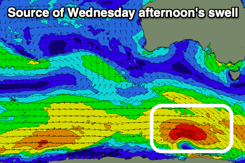
This is being generated by a strong polar fetch of W/NW gales around a polar low that’s to our south-west, with it expected to pulse to a good 3ft on the sets across Clifton. Ahead of this, tomorrow should be 2ft and each morning conditions will be clean with a light to moderate N’ly breeze tomorrow, strong E/NE-NE into the afternoon and then moderate N/NE tending lighter E/NE winds Wednesday.
Our onshore change for Thursday is still unfortunately on track with strong W/SW-SW winds due, creating choppy conditions, tending back W/NW for Friday morning.
Swell wise, a localised windswell from Thursday’s change should come in at 2ft, easing through the day.
Into the weekend we’re looking at moderate sized + mid-period S/SW swell, generated by a strong and sustained polar frontal progression projecting up and into us later week.
The swell is due to build Saturday from the SW but with poor, strong SW winds, peaking Sunday morning from a S/SW direction with W/NW-NW winds.
Size wise Clifton should come in around 4ft but we’ll review this on Wednesday. Have a great Christmas!