Easing surf into the end of the week, solid next week

Southern Tasmanian Surf Forecast by Craig Brokensha (issued Wednesday November 8)
Best Days: Tomorrow morning, Friday morning, Sunday morning, Monday morning, Wednesday morning, Thursday morning
Features of the Forecast (tl;dr)
- Fun mid-period SW swell for this afternoon, easing tomorrow with light S winds and fresh S/SE sea breezes
- Fading surf Fri with N winds ahead of S/SE sea breezes
- Tiny Sat with strengthening S/SW winds
- Small, inconsistent W/SW swell Sun with W/NW winds, strengthening from the W through the day
- Moderate sized SW swell Mon with NW tending W/NW winds, then W/SW into the PM
- Stronger SW groundswell building Tue, peaking in the PM with fresh W/SW tending strong S/SW winds
- Easing swell Wed with variable tending S/SE winds
Recap
Clean but generally tiny yesterday, while today some new swell is building with clean conditions and surf to 1-2ft that's now more so 2ft but with onshore winds.

Kick in swell to 2ft this arvo but with onshore winds
This week and next (Nov 9 - 13)
Today's small increase in swell is due to fade through tomorrow, further into the weekend ahead of a small bump of W/SW swell on Sunday.
Tomorrow morning should still be 2ft, 1-1.5ft on Friday, and conditions are a little dicey tomorrow as a trough leaves light S winds that will freshen from the S/SE through the day.
Friday looks cleaner with N'ly morning winds before the S/SE sea breezes kick in.
Saturday will be a lay day with tiny surf and onshore S/SW winds thanks to a trough moving in from the west, but a return to W/NW winds is due Sunday, strengthening from the W through the day.
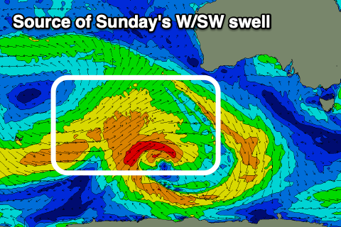
This will be with an inconsistent pulse of W/SW swell, generated by a slow moving polar low that's currently south-west of Western Australia.
A small 1-2ft of swell is due, but there are more interesting developments due into next week.
Behind the low generating Sunday's swell, a secondary stronger and closer positioned low is due to form, south-west of us on the weekend, followed by a third even stronger low Sunday/Monday.

The second low should generating strong to gale-force W/SW winds through our south-western swell window, producing a moderate sized mid-period SW swell for Monday to 3ft to occasionally 4ft across Clifton.
The third low will produce an elongated fetch of W/SW gales and a larger groundswell for Tuesday, peaking into the afternoon to 5ft across Clifton, then easing from 4ft on Wednesday.
NW tending W/NW, then W/SW winds are due on Monday, while Tuesday looks dicey thanks to fresh W/SW tending strong S/SW winds.
Variable breezes will create cleaner conditions on Wednesday as the strong swell eases.
We may see a further pulse of reinforcing swell late week but we'll look at this closer on Friday.