Fun surf over the coming days, trickier weekend

Southern Tasmanian Surf Forecast by Craig Brokensha (issued Monday October 9th)
Best Days: This afternoomn ahead of the change, tomorrow morning, Wednesday morning, Friday morning, Saturday morning, Sunday morning
Features of the Forecast (tl;dr)
- Easing mix of swells tomorrow with variable tending SE winds
- Late pulse of S/SW groundswell tomorrow, peaking Wed AM with NW tending E/NE winds
- Moderate sized W/SW swell building Fri with W/NW tending SW winds, easing Sat with NW tending SW winds
- Mix of swells Sun/Mon with early NW winds Sun, strong SW Mon
Recap
Cleaner but large surf that was overpowering Clifton on Saturday, better Sunday morning with nice, clean conditions and smaller surf.
Into the afternoon a strong new S/SW groundswell arrived and this is easing today from 2-3ft along with a long-range W/SW groundswell in the mix. Conditions are clean and still good this afternoon so make the most of it. Winds are due to shift SW late afternoon so surf now.

Good sized mix of swells this afternoon
This week and weekend (Oct 10 - 15)
A trough linked to this afternoon's late change will clear to the east tomorrow resulting in variable winds tomorrow morning ahead of sea breezes.
The mix of swells today are due to ease back from 2ft+, while a burst of strong SW winds in our southern swell window today should produce a reinforcing pulse of S/SW swell Wednesday to 2ft+ (3ft sets likely), easing through the day.
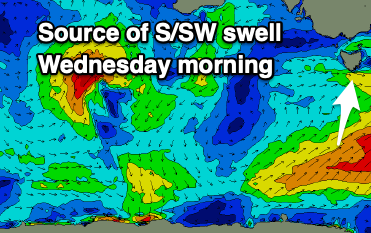
Conditions should be nice and clean again on Wednesday morning with a NW offshore, shifting E/NE through the afternoon.
Tiny surf is then due into Thursday ahead of building levels of mid-period W/SW and SW swell Friday through the weekend.
This will thanks to a strengthening frontal progression directly south-west of us later week with strengthening fetches of W/SW-SW winds due to be projected through our western and south-western swell windows.
This will produce building levels of weak, mid-period swell that looks to Friday but more so on the weekend.
The models diverge a little on the make up of this progression but at this stage Clifton looks to come in around 2-3ft Friday afternoon and Saturday morning, with some further swell on the cards for early next week.
Winds will vary with each passing front but the mornings look clean at this stage with bumpy afternoon's.
We'll have to nail down the timing and sizes on Wednesday though.