Tiny ahead of more action later week

Southern Tasmanian Surf Forecast by Craig Brokensha (issued Monday September 25th)
Best Days: Thursday, Friday morning, Saturday
Features of the Forecast (tl;dr)
- Tiny background W/SW energy tomorrow, easing Wed
- New mid-period swell for Thu with W/NW winds
- Mix of inconsistent W/SW groundswell and close-range swell Fri with strong W/NW tending SW winds
- Easing surf Sat with N/NE winds
Recap
Tiny, clean surf all weekend, bottoming out this morning.
This week and next (Sep 26 – Oct 1)
It’s great to be back in the saddle after a couple of weeks offline, and looking at the week ahead it's expected to be generally tiny and slow, with a new mix of better swells due later week.
The models are showing a slight lift in size tomorrow but its source was in our far, far swell window and isn't likely to top 1ft.
Into the end of the week a better mix of W/SW groundswells are due, with a strong frontal system that's currently north-east of the Heard Island region due to track east-southeast while weakening this evening. A fetch of gale to severe-gale W/NW winds should generate a small 1-2ft of inconsistent W/SW groundswell for Friday, but following this the remnants of the progression will move in under the country, with additional fronts firing up right under us later week.
This looks to add some additional more consistent W/SW energy to the mix, with the first generating a small lift in swell Thursday to 1-2ft, while Friday should hopefully see surf more to 2ft.
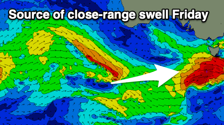
Local winds look favourable Thursday and out of the W/NW most of the day, deteriorating Friday with strengthening W/NW tending SW winds as the swell generating front moves through.
Saturday should still be around 2ft and with N/NE winds, favouring some breaks over others.
Longer term there's nothing major on the cards for next week with a mix of W and possible small S/SE swells on the cards. More on this Wednesday.