Rare S/SE groundswell with good winds tomorrow ahead of a near-flat weekend

Southern Tasmania Forecast (issued Wednesday 7th May)
Best Days: Thursday, early Friday, late Monday, Tuesday
Recap
A strong and powerful S/SW groundswell filled in yesterday, offering good waves in protected locations as winds tended more S'ly during the day. This was generated by a vigorous low pushing up into the state before moving to a position off our East Coast.
The swell dropped rapidly back into today, but a new S/SE groundswell should of arrived late this afternoon, generated by an additional fetch of severe-gale S'ly winds wrapping into the bottom of the low. Conditions would have been poor anyway though with a S/SW breeze.
This week (May 7 - 9)
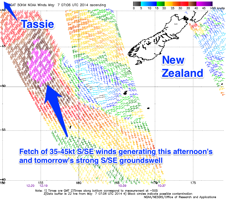 As touched on above, a fetch of severe-gale S'ly winds feeding into the southern flank of the deep low that produced yesterday's S/SW groundswell should of generated a strong and rare S/SE groundswell for us this afternoon (pictured right).
This swell should of reached 4-5ft across Clifton and through tomorrow we should see the swell drop steadily away from 3-4ft+ or so. More exposed locations will see a touch more size and with NW tending variable winds, there should be plenty of options.
Come Friday there's not expected to be much above 1-2ft leftover but fresh N'ly winds will favour exposed spots.
This weekend onwards (May 10 onwards)
The weekend is still expected to be tiny to flat with the next significant increase in swell due later Monday and Tuesday morning.
This will be a very inconsistent and long-range W/SW groundswell, generated by a vigorous polar frontal progression in the Heard Island region. The wind strengths and broad nature contained in this progression will help override the large distance from the source to our coasts, but still only a very inconsistent 2ft wave is due later Monday before easing from a similar size Tuesday.
Winds on Monday evening should be favourable and light from the NW, while Tuesday will also be clean with a N/NW breeze, favouring more exposed locations.
Beyond this there's nothing too significant on the cards unfortunately so therefore make the most of tomorrow's S/SE groundswell and check back for an update Friday.