Not a particularly exciting outlook period

South-east Queensland and Northern NSW Surf Forecast by Ben Matson (issued Wed Dec 13)
Features of the Forecast (tl;dr)
- No major swell events throughout the forecast period
- Small swells with northerly winds for Thurs/Fri
- Chance for variable winds at times on the MNC, shallow S'ly change Fri AM
- N'ly winds Sat, S'ly winds Sun, variable Mon, then back to N'ly winds Tues onwards
Recap
Tuesday delivered really nice, easing surf from the E/NE with 3-4ft sets and light morning winds, even the afternoon sea breeze didn’t amount to much in many areas. Today’s seen much smaller, weaker surf from the E/NE and the new southerly groundswell has come in much smaller than expected across Northern NSW, with slow, inconsistent 2-3ft sets at south swell magnets at best. This is in stark contrast to Sydney, which picked up solid 4-5ft sets, and some parts of the lower Mid North Coast which were reportedly 6ft+ this morning.
This week (Dec 14 - 15)
The rest of the week looks very ordinary for SE Qld, mainly due to a freshening northerly flow. There won’t be a lot of surf on offer anyway, just a minor mix of energy from the E/NE and S.
The same swell trend will apply across Northern NSW and the Mid North Coast, and freshening N/NE winds adjacent the Northern NSW coast on Thursday will build some local windswell across the region (though of very low quality).
However, surface conditions look tricky - an approaching trough and trailing southerly change will create pockets of light variable winds south from about Yamba. Friday in particular has some mild promise, as we’ll see the southerly change nose into the lower Mid North Coast during the morning, though it’s expected to peter out around Coffs or thereabouts. So slack winds are likely for the afternoon.
However, these potential windows of opportunity won’t accompany any great surf prospects so keep your expectations low in general.
This weekend (Dec 16 - 17)
The weekend still looks pretty craptacular.
On Saturday, a small long period S’ly groundswell is expected to make landfall across south facing beaches south of Byron, generated by a trailing front in the Southern Ocean earlier this week. There won’t be a lot of size on offer, but more defined 2ft+ sets should show at the region’s more reliable south swell magnets.
Otherwise, minor background E’ly swells and some local N’ly windswell will pad out remaining coasts.
Saturday’s winds look to be freshening northerly all day, swinging to the south across all regions on Sunday (then SE in southern regions) in the wake of a weak trough that may form a small low off the Northern NSW coast (see below).
Model guidance doesn’t offer a whole lot of potential from this low, but I’ll keep a cautious eye on it for now as we may see some short range energy fill in across Northern NSW throughout the day. Of course, local wind prospects don’t look very favourable right now either.
Next week (Dec 18 onwards)
Persistant troughiness will linger across the coastal margin for much of next week, but there’s still no sign of any major swell generating systems.
The small low forming off the North Coast on Sunday may provide some small surf for Monday, however northerlies look like they’ll soon make a return too, and may dominate the region for much of the working week.
Additionally, we have some developing trade flow out near Fiji for the long term but no major size is expected from this region either. A small tropical cyclone could form out across the eastern Fijian region this weekend but it doesn’t hold much size potential right now.
All in all, the lead up to Xmas is looking a little on the small side. But I’ll have more on that in Friday’s update.
Comments
zzzzzzzz.. back to bed
"The rest of the week looks very ordinary"
"keep your expectations low in general."
"The weekend still looks pretty craptacular."
"wind prospects don’t look very favourable right now either."
Always glass half empty with this guy ;-)
I think he's hurting like the rest of us Sprout. Its been a shit run
Oh no doubt it's been terrible, just havin' a dig back at my mate haha.
Tellin it like it is. Pretty low expectation stuff. At this time of year anything remotely surfable on suitable equipment is good surf.
Hang on we are in summer now so we shouldn't be getting week long stints of fcking Nly winds!!! So over this spring like shit. Only good thing is as each day goes by we're one day closer to Autumn!!!
From memory this is a 'normal' summer with ne winds .........should turn around in feb......from memory......haha
i havent read one of these articles for ages now. the title is enough to make me close the window
jeez... been busy and living in Brisbane the past few months, feeling depressed for not getting many waves. nice to know I haven't been missing too much.
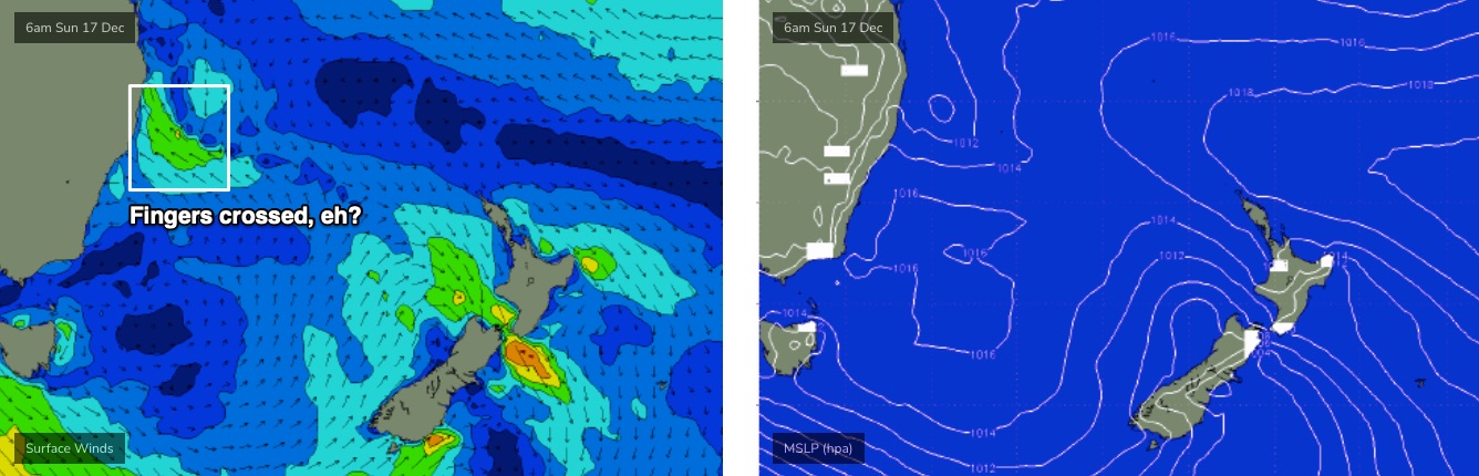
Appreciate its some time away but GFS has an interesting forecast for a restrengthening Jasper in the gulf.
Haha, yes. The 18Z run even has Jasper moving back into the Coral then tracking SE right across - you guessed it - NZ North Island.
Stranger things have happened, but I hope this doesn't.
about now some smart arse pipes, up with "hey tI have been getting heaps of waves - just gotta no where to look," insinuating there are secret spots on the GC or SC that love a Howling Northerly and no swell
on that i did get some fun shorey waves on the high tide this morning....
Yeah clean 2fters is something at least.
Impressive fetch length and duration out in the tropical
South Pacific coming up. Could be a good run of some very fun Ely swell coming. Just need the Fcking local winds to play ball now.
Water has gone absolutely freezing here.
Coldest of the year.
Found fun 2-3ft surf at a S swell magnet between here and Coffs yesterday.
You obviously got some shelter from the howling N'lys then.
Wind was slack until 10am
Still toasty and 21-22°C on the beaches even after a strong NE blow Wednesday evening.
Freezing here- says 21 on the buoy- probably 18 inshore.
Deffo coldest water of the year.