Fresh south swells ahead for Northern NSW; small in SE Qld

South-east Queensland and Northern NSW Surf Forecast by Ben Matson (issued Monday 7th August)
Best Days: Wed/Thurs: fun south swell in Northern NSW with morning offshores. Only small in SE Qld. Fri: strong S/SE swell, wth NW winds. Good (smaller) surf across open beaches in SE Qld, mainly Gold Coast (smaller Sunny Coast). Sat: fun beachies though easing rapidly.
Recap: A fun small E’ly swell provided good waves across the Mid North Coast on Saturday with sets up to 2ft+, a little smaller across Far Northern NSW and not very much across SE Qld. The swell faded slowly throughout Sunday and today has seen only a minor N’ly windswell across exposed north facing beaches.
This week (August 8th - 11th)
A deep Tasman Low is forming east of Tasmania, and strong fronts wrapping around its western flank will generate fresh southerly swells for the middle to latter part of this week. However only Northern NSW will pick up any notable size from this progression; SE Qld looks like it’ll be out of the firing line so away from exposed northern ends it’ll be pretty small.
The models are undercalling this event, mainly due to the SW fetch direction - which will create a very wide range in size between exposed south facing beaches and protected locations - however we’re looking at four days of varying degrees of south swell as various segments of the low send a series of small to moderate, back-to-back pulses of south thru’ south/south-east energy to Southern NSW.
The first pulse of south swell will push up along Southern NSW on Tuesday but I’m not confident that we’ll see much, if any size across Northern NSW by the end of the day. The Lower Mid North Coast is probably your best chance, but even then only exposed south swell magnets are likely to see anything rideable.
Wednesday is a better chance all round, with the south swell expected to provide 3-4ft sets at south facing beaches south of Byron, and much smaller surf elsewhere. SE Qld won’t see much size but exposed northern ends may rake in the odd 2ft+ set (Gold Coast, smaller on the Sunny Coast). Winds should be out of the western quadrant just about everywhere, maintaining clean conditions.
On Thursday, this pulse will ease slowly back in size throughout the day (though the models suggest it’ll hold steady.. I disagree with this), and early offshore winds will give away to a freshening northerly breeze in the afternoon. So aim for a morning surf for the most size and cleanest conditions.
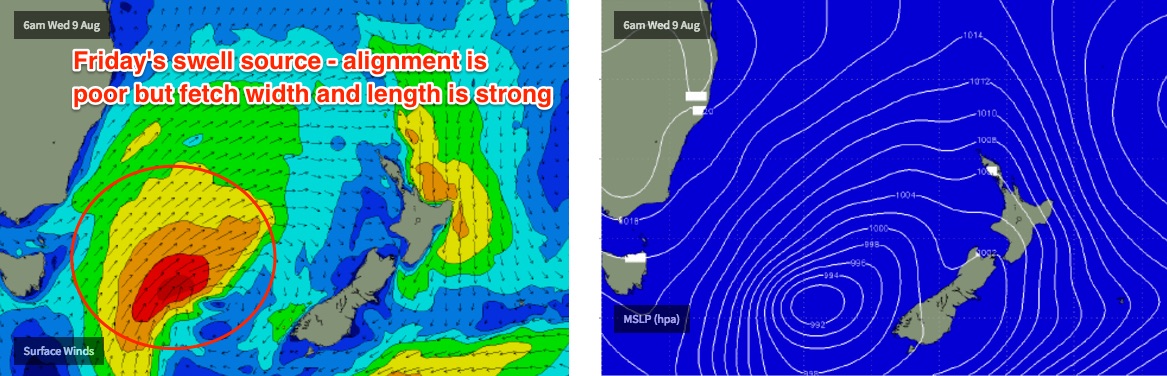
Very late afternoon, a new pulse of stronger S/SE swell will start to fill into Southern NSW, reaching the Lower Mid North Coast overnight and extending across Far Northern NSW and SE Qld throughout Friday. Winds should back to the NW as a series of new fronts approach from the south-west, and there’s a risk for a northerly tendency at times too.
The new swell will be larger and with a longer period, originating from the Tasman Low as it reaches maturity in the southern Tasman Sea around Wednesday. There’ll be a wide range in size (as per usual for a south swell) but south swell magnets south of Byron could be looking at 4-6ft sets (note: this is much higher than our models are calling), but most open beaches will be significantly smaller, around 3ft.
The problem on Friday is whether this swell will be too large for those beaches picking upon the size, as the wind will be poor for the points. Aim for a slightly more sheltered open beach for the best waves.
North of the border, winds will be ideal for the beach breaks on Friday, and exposed northern ends of the Gold Coast could see 2-3ft+ sets, with smaller 2ft sets across the Sunny Coast. This is probably the best day of the forecast period for this region.
Also in the mix this week will be a couple of minor easterly swell pulses but they’re not really worth going into too much detail about.
This weekend (August 12th - 13th)
Winds look tricky for the weekend, with a small weak low currently expected to form off the North Coast. This won’t be a swell generator but at the moment it throws a curveball regarding local winds.
Friday’s solid S/SE swell will ease through Saturday so we’ll be working around this event. Expect 3-5ft sets at south swell magnets south of Byron early Saturday morning, easing to 2-3ft rapidly throughout the day. North of the border, exposed northern ends may see early 2ft+ sets but it’ll be much smaller by lunchtime and into the afternoon.
As for the rest of the weekend, a strong succession of powerful fronts exiting eastern Bass Strait from Friday onwards look a little too westerly in alignment to benefit our coast, however this is our only other source of swell for the weekend.
Being an optimist, there’s a chance for 2-3ft+ sets at south swell magnets in Nortern NSW from late Saturday (Mid North Coast) and into Sunday (remaining Northern NSW coast) but a lot of locations will probably dip out completely due to the acute swell direction. Especially SE Qld.
Let’s take a closer look on Wednesday.
Next week (August 14th onwards)
There’s nothing of great interest in the long range charts, however I do note that there is a suggestion for a small tropical feature to drift south of the Fijian region early next week which may provide a mid-late week round of E'ly swell for us. I’ll keep a close eye on this in the coming days.
Comments
Looks like there's a slight lag on the new south swell in Far Northern NSW.. wasn't a lot of swell on the Tweed this morning (though it had come up a little since yesterday).
However the Coffs buoy is showing a nice jump this morning:
There ain't much happening across most SE Qld beaches this morning (as expected) though interestingly - despite the apparent lag across Northern NSW - Moffats on the Sunny Coast was picking up some small but seemingly consistent lines a short time ago (see pic below).
Local buoy data would suggest that we saw a minor S'ly swell push up across the region overnight - the first in the series - but it eased rapidly across Northern NSW and the Goldy before sunrise. However, it seems to be showing a few lingering sets across the Sunny Coast (they will abate over the coming hours).
The new swell currently showing at Coffs is a second pulse of stronger energy, and it is expected to provide the bulk size today - Southern NSW came in strong mid-late yesterday with afternoon sets around the 4ft mark, which is within forecast expectations - so confidence is still pretty good that we'll see some fun waves across Northern NSW today.
Stunning weather too, eh?
Straight lines on the Tweed Coast, nice and clean though only small.
Nice lines in Coffs.
Hopefully it will hang in or increase this afternoon for tomorrow