The come-down is real

South Australian Surf Forecast by Craig Brokensha (issued Monday February 5th)
Best Days: No good days, possibly Sunday morning but most likely early next week
Features of the Forecast (tl;dr)
- Easing S/SW groundswell tomorrow with fresh S winds, smaller Wed with moderate S/SE winds, strengthening
- Small swell Thu with SE tending S/SE winds
- Poor Fri with strengthening S/SE winds
- Large S/SW groundswell building Sat with mod-fresh SE winds, strengthening from the S/SE
- Easing swell Sun with possible early variable winds, increasing from the S'th
- Smaller Mon with NE tending SE winds
- New S/SW swell Tue with strengthening N/NE tending N/NW winds
Recap
Pumping surf on Saturday with a large S'ly groundswell under offshore winds that saw the deep water reefs awaken on the South Coast and epic waves for the Seaford Boardriders first event of the year. Yesterday morning was smaller but nice and clean again ahead of a fresh pulse of SW groundswell into the afternoon though with an onshore change.
The Mid Coast offered inconsistent but fun 1-2ft sets on Saturday, back to 1-1.5ft yesterday and clean through the morning.
Today, we've got onshore winds and an easing pulse of SW-S/SW groundswell that filled in yesterday afternoon.

Big sets with offshore winds Saturday morning
This week and weekend (Feb 6 - 11)
I hope you made the most of the recent run of waves as the coming week is average at best.
Yesterday's change associated with a trough will linger all this week across the South Coast with small, weak swells and nothing to surf on the Mid Coast.
Fresh S'ly winds will persist tomorrow with a smaller swell, weaker but still moderate from the S/SE on Wednesday but with no decent surf.
Winds are expected to shift SE into Thursday morning but with 1-2ft of background swell while strengthening S/SE winds will kick in on Friday.
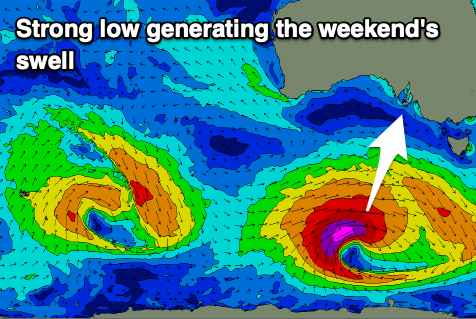
We then look to the weekend, and another large pulse of S/SW groundswell due across the South Coast, generated by another tropical system drifting in from the Indian Ocean, absorbed into the westerly storm track.
This will see a strong polar low forming in our southern swell window, with a fetch of severe-gale to storm-force W/SW-SW winds forecast. EC has this low being a touch weaker than GFS, resulting in less size so we'll have to update the expected size in Wednesday's notes.
Regardless we're probably looking at surf to 5-6ft later Saturday afternoon and evening down South, tiny on the Mid Coast, easing rapidly from 4ft on Sunday morning.
Winds will unfortunately still be out of the SE Saturday morning and moderate to fresh, strengthening from the S/SE through the day with more variable winds a chance for a short period on Sunday but we'll review this on Wednesday.
Early next week looks active with fun levels of S/SW swell on the cards with better winds but we'll look at this in more detail Wednesday.