Windows for the South Coast with a dynamic low

South Australian Surf Forecast by Craig Brokensha (issued Monday January 15th)
Best Days: Keen surfers on the magnets tomorrow morning, possibly Thursday morning protected spots, Friday morning, Saturday morning
Features of the Forecast (tl;dr)
- Small, fading S/SW swell tomorrow with N/NE winds ahead of strengthening S/SW change midday/early PM
- Fresh to strong S-S/SW winds Wed with a small increase in windswell
- Moderate sized, weak S/SW swell Thu with W/SW-SW tending S/SW winds (possibly W/NW around Victor early)
- Large S'ly swell Fri AM, easing with light E/NE tending SE winds
- Rapidly easing S swell Sat with N/NE tending S/SE winds
Recap
Friday's fun W/SW swell backed off into the weekend with clean conditions on the Mid Coast and 1ft waves hidden under the big morning high tide, flat yesterday.
The South Coast was poor and onshore with nothing to recommend following Friday's surf.
Moving into today we've got some new mid-period S/SW swell and easing S/SE windswell with more variable winds and surf to 2-3ft.
This week and weekend (16 - 21)
We've got a dynamic week of weather and surf ahead as a mid-latitude low moving in from the west combines with a polar front approaching from the south-west, resulting in the deepening of the low mid-late week. The low will actually stall just off the Tasmanian coast, in our southern swell window Thursday, but more on this below.
Looking at tomorrow and the current mix of swells will be small, weak and fading from 1-2ft with a great offshore N/NE breeze that will tend variable ahead of a S/SW change around midday/early afternoon. If you're keen for a surf hit the swell magnets.
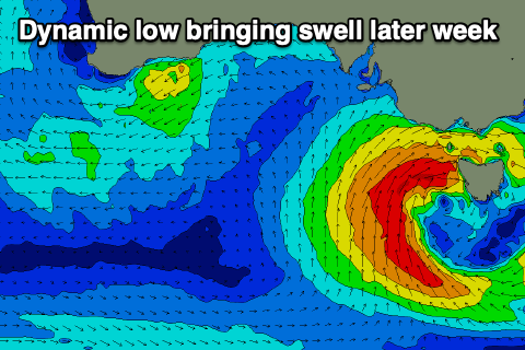
Unfortunately we'll fall under the southern flank of the low as it deepens and stalls west of Tasmania into Wednesday/Thursday, with fresh to strong S-S/SW winds due on the former, weaker into Thursday and tending more W/SW-SW. This may allow winds tend W/NW around Victor for a short period in the morning thanks to local topography with some weak S/SW swell to 4ft across Middleton and some tiny windswell on the Mid.
Into Friday stronger levels of mid-period S'ly swell are due, generated by gales around the western flank of the low Thursday, producing a spike to 5-6ft in the morning across Middleton, easing through the day. The Mid won't see any of this swell, fading from 0.5-1ft.
Winds on Friday will swing E/NE as the low moves across Tasmania, further east, creating decent conditions for experienced surfers down South, great Saturday morning with a light offshore wind and N/NE offshore. Easing sets from 3ft+ are likely, dropping quickly through the day.
Longer term small S/SW swells with varying winds from the eastern quadrant are due next week but more on this Wednesday.
Comments
Hey Craig, which part of the Yorke is the "surf forecast" for? Guessing the West side of the Yorke will get nada from this close range swell?
Yeah west side. Very tricky swell source, Thursday will see the most size from the front pushing up behind the low, while the swell from the low won't likely provide any surf at all Friday, blocked by KI.
Cheers