Slim window tomorrow morning, better next Thursday

South Australian Surf Forecast by Craig Brokensha (issued Friday December 22nd)
Best Days: Keen surfers tomorrow morning South Coast, similar Wednesday, South Coast Thursday ahead of the change
Features of the Forecast (tl;dr)
- Small-mod sized mid-period S/SW-SW swell for tomorrow with early variable winds, tending S/SE-SE and then freshening into the PM
- Strong S winds Sun and Mon AM, tending S/SW into the PM
- Moderate sized SW groundswell Mon AM, easing Tue
- Stormy S windswell also in the mix Sun-Tue
- Strong S winds Tue
- Moderate sized mid-period S/SW swell Wed with weaker S winds
- Easing swell Thu with NE tending NW winds ahead of a strong S/SW change in the PM
Recap
After a fun day of surf Wednesday across the Mid Coast, the swell faded back to a tiny 0.5-1ft yesterday, while the South Coast saw poor, strong onshore winds. This morning the swell is smaller down South with a weaker onshore wind.
This weekend and next week (Dec 23 - 29)
Looking at the weekend ahead, and our window of variable winds for tomorrow morning down South is still on track but it looks short-lived. The lower resolution models aren’t picking it up, but the higher resolution models have a variable breeze at dawn, though coming up from the S/SE-SE through the morning.
It’s not worth chasing too hard but if in the area set the alarm for the early for some OK, lumpy waves. A new mid-period S/SW-SW swell should also be in the water with sets to 2-3ft across Middleton, mixed in with some weaker windswell.
Sunday will be a write-off with the trough linked to tomorrow’s variable winds due to shift east, leaving strong S winds in its wake.
Moving into the Christmas week, and Christmas Day looks cool and windy with persistent strong S’ly winds across the South Coast, tending S/SW into the afternoon and then persisting Tuesday out of the S’th. This will whip up a weak, tiny windswell on the Mid Coast but with no quality, solid down South but a total mess.
There’s also due to be some SW groundswell in the mix Monday afternoon and Tuesday morning but it’ll be impossible to decipher under the local windswell.
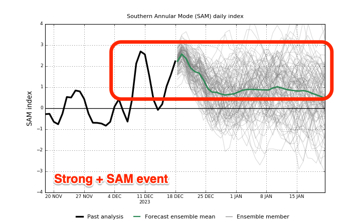
This run of poor weather and onshore wind is thanks to a strong + Southern Annular Mode event (above left) which sees the westerly storm track retract towards Antarctica (while strengthening), and higher pressure dominate the mid-latitudes.
Onshore winds are expected to start easing on Wednesday (light to moderate S/SE) as a trough approaches from the west, but Thursday morning now looks like the best shot with NE tending NW winds ahead of a strong S/SW change as the trough moves through.

A fun sized, mid-period S/SW swell should be in the water on Wednesday, generated by a good fetch of strong W/NW winds moving under the country on the weekend, with a polar low generating an additional fetch of W’ly winds. This should produce 3ft sets across Middleton Wednesday with that workable, weak onshore wind, best Thursday with easing 2-3ft sets.
Moving into the end of the week and next weekend, poor, strong S/SW winds are due Friday, weaker and tending more SE Saturday/Sunday along with small to moderate levels of SW swell. More on this Monday. Have a great weekend!
Comments
Summer?
We need a wave pool.
I hate you wind
drove down the coast from Sydney and via Torquay over the last 7 days... skunked the whole way and now the Victor Harbor area for a week looks like a skunkfest.
Get a mountain bike. Just don't get a specialised and cruise around in a pack with a bunch of other newbies on specializeds
I’m so sick of these summers we get now it’s like we are the new Victoria what happened to getting WA,s weather this is four years in a row of cool summers
Interesting comment but only really applies to when th fronts are coming through in autumn/winter/spring. Then the weather will come from the west.
Right now with the highs sitting south all the weather is coming from the east and south-east so no good.