Make the most of tomorrow

South Australian Surf Forecast by Craig Brokensha (issued Wednesday October 18th)
Best Days: Tomorrow South Coast, Friday morning, keen surfers Monday morning down South
Features of the Forecast (tl;dr)
- Moderate sized S/SW groundswell for tomorrow with N'ly winds ahead of weak sea breezes
- Fading swell Fri with fresh N/NE tending N/NW winds
- Strong SW winds Sat with a building W/SW windswell on the Mid and S/SW swell down South
- Mod-large mid-period S swell Sun with strong S/SW winds
- Easing S swell Mon with E/NE-NE tending SE winds
- Tiny Tue with strong N tending W/NW winds
- New W/SW windswell next Wed with strong SW winds and a building S swell down South, peaking Thu with S/SE winds
Recap
Tiny 1ft surf on the Mid Coast yesterday, full and clean in the morning while becoming more consistent but bumpy into the afternoon. The South Coast offered plenty of size with surf to 4ft through the morning off Middleton but with lumpy, peaky conditions.
This morning is much smaller and back to 2ft across Middleton as 0.5-1ft sets linger on the Mid Coast.
This week and next (Oct 19 - 27)
Our fresh pulse of S/SW groundswell due into tomorrow morning is on track and it's worth making the most of as the rest of the period will see a cycle of building swell with strong onshore winds, easing while slowly improving and cleanest as the swell fades.
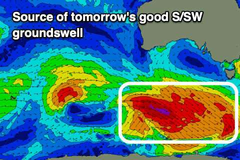
Tomorrow's swell was generated by a strong polar low, producing a fetch of gale to severe-gale W/NW winds south of the country earlier this week.
A good kick in size to 3-4ft is due tomorrow morning with light N'ly offshore winds, ahead of relatively weak sea breezes.
The Mid Coast won't see much size from this swell, with it coming in at 1ft max on the favourable parts of the tide.
Come Friday, the swell will be fading and easing from 2ft across Middleton with fresher N/NE winds, shifting N/NW into the afternoon as the swell continues to ease.
Moving into the weekend and a deepening trough come low will bring strengthening SW winds into Saturday along with a low quality, building S'ly swell through the day, peaking Sunday.
Strong to gale-force S'ly winds developing west of Tasmania and south of the South East should kick up 4-6ft of swell Sunday morning but with strong S/SW winds. The Mid Coast will also see some tiny, localised windswell but to no major size.
Come Monday the low will move to the east allowing winds to shift to the E/NE-NE through the morning but conditions will be similar to yesterday, lumpy and peaky with easing sets from 3ft+ across Middleton.
A strong N'ly wind will move in Tuesday ahead of the next deepening mid-latitude low but size wise, the South Coast will be tiny and poor.
This next low will move quickly through our swell window, bringing onshore SW winds Wednesday along with a mix of new W/SW and building S/SW swell, peaking Thursday as winds shift S/SE.
Unfortunately for the Mid, by the time winds swing S/SE on Thursday the swell looks to become tiny again while the South Coast will be large but onshore.
Longer term there's nothing too significant swell quality wise on the cards so make the most of tomorrow!