Fun waves for the South Coast over the coming days

South Australian Surf Forecast by Craig Brokensha (issued Monday October 9th)
Best Days: South Coast tomorrow morning and Wednesday, Mid Coast for the keen Friday and Monday
Features of the Forecast (tl;dr)
- Easing SW groundswell this afternoon, with a reinforcing mid-period W/SW swell tomorrow, easing Wed
- E/NE-NE tending SE winds tomorrow
- Moderate N/NE tending stronger N/NW winds Wed
- Moderate sized mix of W/SW swells building Thu PM, peaking Fri
- Strong W/NW-W winds on Thu, fresh SW Fri, easing (early W/NW winds possible Victor)
- Building weak SW swell Sat with W/NW winds
- Moderate sized S/SW swell building Sun with strong SW winds, easing Mon with mod-fresh S/SE winds
- Smaller Tue with NE tending SE winds
Recap
Friday's large pulse of SW groundswell started to ease through the weekend but Saturday morning was still large and lumpy, with a few novelty breaks firing up, clean and fun on the Mid Coast and to 1-2ft.
Yesterday became tiny in the gulf while the South Coast was workable with the size holding in the 3-4ft range under a morning NE breeze.
Today, a reinforcing SW groundswell is maintaining 3-4ft sets across Middleton with a light E/NE breeze and the Mid is a micro 0.5-1ft and best for beginners on the beaches.
This week and weekend (Oct 10 - 15)
This morning's reinforcing SW groundswell is due to ease through this afternoon, but a slightly smaller, weaker mid-period W/SW swell should maintain 3ft sets across Middleton tomorrow and 0.5-1ft sets on the Mid Coast, fading through Wednesday.
Winds will again be E/NE-NE tomorrow morning across the South Coast ahead of sea breezes, while Wednesday looks the cleanest with fading 2ft+ sets across Middleton and better, moderate N/NE tending stronger N/NW winds into the afternoon.
A shift in winds to the W are due on Thursday as a mid-latitude front pushes in from the west, bringing an increase in windswell and mid-period swell through the afternoon, easing Friday.
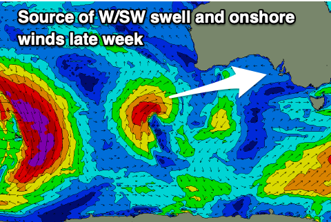
The low is currently south-west of Western Australia, generating a fetch of strong W/SW winds and will move slowly east, towards us over the coming days while weakening.
A fun, moderate sized mid-period W/SW swell will be generated by the low, arriving Thursday afternoon, peaking overnight but most likely showing the most size Friday morning.
The Mid Coast should see consistent 2-3ft waves into later Thursday and all day Friday, while the South Coast looks to come in around 3-4ft across Middleton. Unfortunately winds look to shift SW on Friday but back off in strength from Thursday, possibly tending W/NW for a period down South.
Into the weekend, we'll see a flurry of late forming (in our swell window), strengthening mid-latitude and polar frontal activity. Back to back fetches of strong W/SW and SW winds should produce building levels of mid-period swell on the weekend and into early next week.
An initial increase in weak, small SW swell is due Saturday, building through the afternoon to 3ft across Middleton, with Sunday possibly increasing more to 4-5ft later in the day, easing from a similar size on Monday.
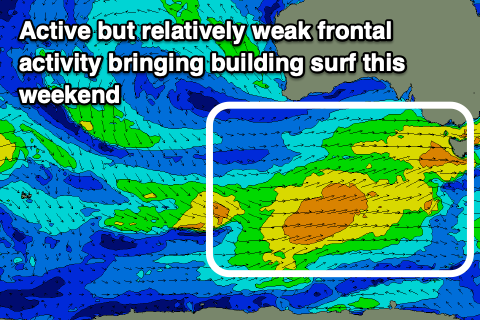
The Mid Coast only looks to come in around 1-2ft through the weekend and Monday morning.
Winds should be W/NW on Saturday but with the weak, small swell, shifting strong SW on Sunday as the swell producing front moves through. This will be then followed by a high, shifting winds S/SE, favouring the Mid Coast Monday but creating poor conditions down South.
Longer term winds look to quickly swing back offshore on Tuesday and some fun mid-period S/SW swell looks to be on the cards for mid-late week. More on this Wednesday though.