Large surf filling in today, easing tomorrow with windows for both regions

South Australian Surf Forecast by Craig Brokensha (issued Wednesday October 4th)
Best Days: Today Mid Coast, South Coast tomorrow, Mid Coast Friday and Saturday morning, South Coast Sunday, Monday and Tuesday mornings
Features of the Forecast (tl;dr)
- Large building W/SW swell today with S/SE winds on the Mid, tending strong S/SW-SW late arvo
- Easing swell tomorrow with W/NW winds down South, W/SW on the Mid
- Large SW groundswell building Fri with mod-fresh S/SE winds
- Large, easing S/SW groundswell Sat with mod-fresh E/SE tending S/SE winds
- Easing surf Sun with E/NE tending S/SE winds
- Inconsistent, moderate sized SW groundswell for Mon AM with E/NE tending S/SE winds
- Easing swell Tue with E/NE-NE tending SE winds
Recap
Clean conditions in protected spots on the South Coast yesterday (before winds strengthened) with surf to 2ft or so, sloppy and deteriorating across the Mid Coast.
Today we've got building levels of W/SW swell and a trough is stalling to our west bringing favourable S/SE winds across the Mid Coast along with 2ft+ sets. We're expected to see the swell build more through the day as winds hold until late afternoon. More on this below.

New swell with favourable winds
This week and weekend (Oct 5 - 8)
Today's large building mix of mid-period and long-period W/SW groundswell are on track but the winds are looking better for the Mid Coast thanks to a trough stalling just west of us before moving in late afternoon.
The Mid Coast should see surf reaching an east 3ft (if not more) with 4-5ft+ sets across Middleton and S/SE winds look to hold in the gulf before shifting SW-S/SW late afternoon and into the evening. The South Coast will see winds strengthen from the S/SW so if keen for a surf around Victor, go soon.
Winds tomorrow still look poor for the Mid Coast but better for the South Coast as the swell eases, with a W/NW breeze now due to hold most of the day along with easing 4-5ft sets across Middleton. The Mid Coast will be bumpy and to 3ft, easing through the day.
A secondary trough will bring poor S/SE winds to the South Coast on Friday while favouring the Mid Coast and we should see a mix of easing W/SW energy and large, SW groundswell on the build.
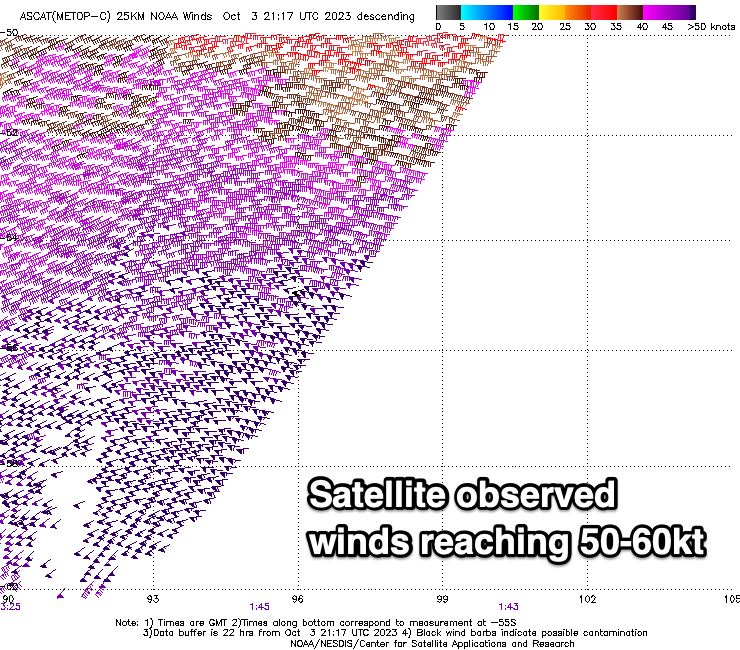
We saw a polar low 'bomb' early in the week, dropping over 24hPa in central pressure within 24 hours, and this has resulted in a fetch of severe-gale to storm-force W'ly winds being generated through our south-western swell window, south-southwest of Western Australia.
Satellite observations have picked up core wind speeds of 60kts and the low is now weakening, with severe-gales continuing through our swell window today before breaking down tomorrow.
A large, long-period SW groundswell is due from the low, arriving Friday and building rapidly into the afternoon.
Middleton should build to 6-8ft with the Mid Coast holding 2ft, dropping back from 6ft+ and 2ft respectively on Saturday morning, smaller Sunday.
Winds will remain average for the South Coast on Saturday and great for the Mid, moderate to fresh out of the E/SE ahead of S/SE sea breezes, with Sunday offering cleaner, peaky options as winds tend E/NE in the morning.

Into early next week, a reinforcing SW groundswell should slow the easing trend with it generated by a trailing frontal system behind the polar low, generating gale to severe-gale W/NW winds today.
Fun, 3ft+ sets should continue across Middleton Monday morning under an E/NE wind, easing into the afternoon with sea breezes, smaller Tuesday but with slightly better E/NE-NE winds.
Longer term a mid-latitude low may bring a windy, stormy swell later week but we'll look at this in more detail Friday. Make the most of the Mid Coast window today and South Coast tomorrow.