Large swell this week, though with poor winds

Hawaii North Shore, Micronesia and PNG forecast by Craig Brokensha (issued on Tuesday 26th February)
This week and next (Feb 26 – Mar 8)
Hawaii: Weak and small surf today, but we should see an initial spike in mid-period N/NW swell tomorrow, though with average N/NE winds across the North Shore. Size wise there's been no change since last update with 4-5ft+ sets due to peak through the day at magnets.
Our larger NW groundswell event for Wednesday/Thursday is still on track, with a very strong but distant and retracting low projecting a fetch of severe-gale to storm-force W/NW winds in our far north-western and then northern swell window.
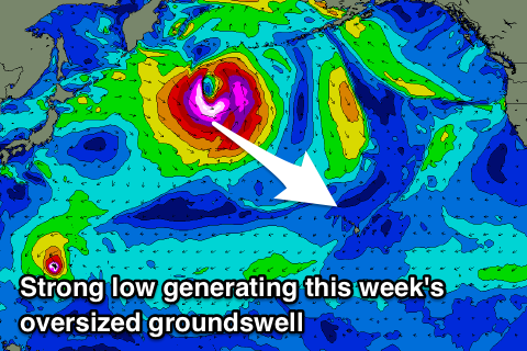 An oversized long-period NW tending N/NW groundswell is expected, building rapidly Wednesday to 10-12ft across the North Shore, peaking overnight and easing back from 8-10ft Thursday.
Unfortunately winds look to remain an issue as a tropical depression projects from the north towards us, bringing gusty N/NE breezes both Wednesday and Thursday. Winds will ease into Friday while tending a little more NE later, persisting Saturday.
Longer term another strong blocking pattern is forecast to setup to our north-west resulting in no significant swell events into the start of March and with persistent N/NE-NE winds.
North Shore Forecast Graph
North Shore WAMs
Micronesia: Swell from Typhoon Wutip should be on the ease today with it fading through tomorrow. There'll be no real quality surfing options over the rest of the week and into next week with small levels of trade-swell easing after a peak Friday.
Gusty E/NE trades will create poor conditions at spots seeing all the size. Mid-late week a bit more size may be seen out of the E/NE, but more on this Thursday. The main take home point is that there'll be no considerable N'ly groundswell events this period.
Palikir Pass Forecast Graph
Palikir Pass WAMs
Papua New Guinea: A fun mix of NW groundswell and NE trade-swell are on the ease and will drop further tomorrow ahead of a low point Thursday morning.
We should see some new trade-swell filling in from the weekend, holding most of next week around 3-4ft, if not for the rare bigger one at times and with variable morning winds.
Later next week a bit more size again is likely as the trade-flow strengthens between us and Hawaii, but more on this Thursday.