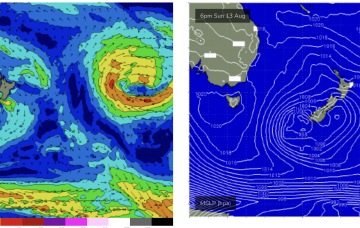
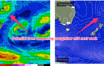
We’ve got a weak, troughy pattern unfolding now adjacent to the NSW Coast in the near Tasman Sea that will provide plenty of wind changes this week. A low pressure system near the South Island reached maximum strength last night and is now slowly easing, but still looking good on ASCAT (satellite windspeed) passes with S’ly strong winds to gales aimed up the Tasman pipe.
Primary tabs
/reports/forecaster-notes/sydney-hunter-illawarra/2023/08/14/nice-s-sse-swell-tomorrow-some-tricky
freeride76
Monday, 14 August 2023
/reports/forecaster-notes/sydney-hunter-illawarra/2023/08/11/fun-options-sat-dynamic-outlook-now
freeride76
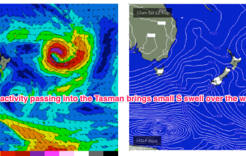
Friday, 11 August 2023
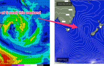
As mentioned on Wed the weekend’s front forms a low which looks to stall in the central/eastern Tasman Sun/Mon, and possibly linger near the South Island after that. The fetch now, isn’t quite so well aimed back at the East Coast but we’re still on track for a nice pulse of S-S/SE swell.
/reports/forecaster-notes/sydney-hunter-illawarra/2023/08/09/small-mixed-bag-continues-improved
freeride76
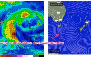
Wednesday, 9 August 2023
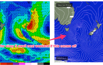
Improved outlook for next week as the weekends front stalls around a trough line in the central/eastern lower Tasman and forms a compact low, possibly even retrograding NW.
/reports/forecaster-notes/sydney-hunter-illawarra/2023/08/07/nothing-major-the-radar-enough-bits-and
freeride76
Monday, 7 August 2023
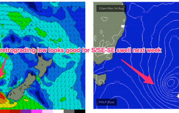
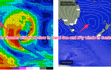
Another large high (1034hPa) is currently moving offshore from Southern NSW into the Tasman, with a long, NW-SE angled trough now moving offshore and towards the North Islands. The remnants of a low/front near the South Island are lingering near the South Island through the short term with the next frontal system expected late this week. No major swell sources on the radar so lets look at a few bits and pieces on offer this week.
/reports/forecaster-notes/sydney-hunter-illawarra/2023/08/04/small-mixed-bag-weekend-best-sat-tricky
freeride76
Friday, 4 August 2023
Sat still looks the best day of the weekend as a trough and front terminating in a compact low approach from the W.
/reports/forecaster-notes/sydney-hunter-illawarra/2023/08/02/good-winds-s-facing-beaches-small-ne
freeride76
Wednesday, 2 August 2023
A massive high (1035 hPa) is currently moving over temperate NSW into the Tasman Sea, with a SE surge extending up the sub-tropical to tropical Eastern Seaboard, and a more N’ly flow south of Seal Rocks. In the wake of a strong front earlier this week we have still have moderate S swell trains propagating through the Tasman Sea which will be our main swell source through the short term.
/reports/forecaster-notes/sydney-hunter-illawarra/2023/07/31/mid-week-s-swell-pulse-then-nly-winds
freeride76
Monday, 31 July 2023
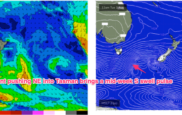
We’ve got a classic winter, stratified pattern with a high pressure belt over the continent, extending out into the Tasman Sea and a robust W’ly storm track below the maritime continent. We’ll see frontal intrusion into the Tasman early this week, with a small front passing into the Tasman today and a stronger system following behind it tomorrow- generating more pulses of S swell mid week.
/reports/forecaster-notes/sydney-hunter-illawarra/2023/07/28/small-clean-weekend-few-different-swell
freeride76
Friday, 28 July 2023
A trough and cold front are being rapidly shunted southwards by a blocking high which is moving NE into the sub-tropical Tasman and weakening. The current swell sources are all drying up leaving us with small background swells.
/reports/forecaster-notes/sydney-hunter-illawarra/2023/07/26/another-long-period-pulse-then-quiet
freeride76
Wednesday, 26 July 2023
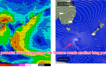
A powerful front has passed through the Tasman, creating our current S’ly groundswell. A more compact but even stronger storm is right behind it, reaching peak strength halfway across the lower Tasman before slamming into the South Island.
/reports/forecaster-notes/sydney-hunter-illawarra/2023/07/24/flukey-long-period-s-swells-and
freeride76
Monday, 24 July 2023
Some powerful but zonal frontal activity will cross the far lower Tasman and send some long period S swell up the Tasman Sea pipe, some of which will wrap into the NSW Coast. Another frontal system then pushes into the Tasman Sea later this week and into the weekend. A typical winter week.