Varying swell pulses and winds
Monday, 3 February 2025
Varying swell pulses and winds
Monday, 3 February 2025
Early mornings will be best over the coming period apart from the days that will be onshore from the get go.
Early mornings will be best over the coming period apart from the days that will be onshore from the get go.
The coming week looks good for surfing across the more exposed parts of the state.
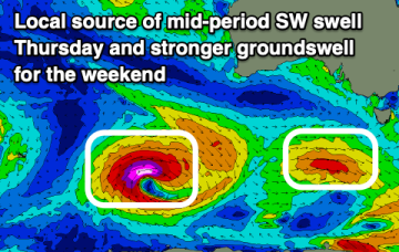
Expect a peak in size over the next 48hrs then a slow ease off through the rest of the week and into the weekend.
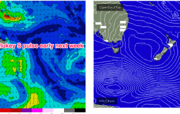
A high pressure in the centre of the Tasman is directing SE-E winds across the sub-tropics, more NE in temperate regions extending down to the Island state. We’ll see more NE windswell episodes in the f/cast period.
Make the most of the clean waves down South before onshore winds kick in tomorrow and the Mid Coast becomes the focus.
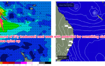
High pressure support for the tropical systems which is currently anchoring a tradewind fetch in the Coral Sea weakens substantially over the short term, with E swell potential thus weakening. We’ll still see plenty of fun E’ly trade swell in the sub-tropics but the top end potential has taken a haircut as well as the duration of the event.
Today is the pick of it for locations west of Melbourne for the coming period. There'll be options to the east through the forecast period.
High pressure support for the tropical systems which is currently anchoring a tradewind fetch in the Coral Sea weakens substantially over the short term, with E swell potential thus weakening. We’ll still see some fun E’ly trade swell in the sub-tropics, trickling down into temperate regions.
An active monsoon trough with various low pressure centres is anchoring a trade-wind fetch through the Coral Sea and extending out into the South Pacific which will see plenty of surf in the CQ region.
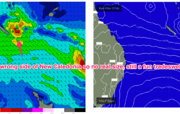
A more classic looking summer chart to start next week with high pressure in the Tasman and low pressure centres near New Caledonia and in the South Pacific slot, with a healthy E’ly tradewind fetch extending across most of the Central and Southern Coral Seas and NE winds in the NETas swell window.