Large swells this week

Western Australian forecast by Craig Brokensha (issued Monday February 3rd)
Best Days: Tomorrow ahead of sea breezes, Wednesday ahead of sea breezes, protected spots later Thursday, Friday morning
Features of the Forecast (tl;dr)
- Mix of large mid-period SW swells tomorrow, peaking in the PM, easing Wed
- Strong E/SE winds tomorrow ahead of sea breezes mid-PM
- Weaker E/SE winds Wed AM ahead of late AM sea breezes
- Large S/SW groundswell building later Thu, peaking overnight, easing steadily Fri
- Strong S/SE winds Thu, weaker E/SE-SE ahead of sea breezes Sat
- Smaller Sat with SW winds, possibly variable Sun AM
Recap
Saturday was average with less than ideal conditions and smaller surf into the morning, while a new pulse of SW swell was seen into yesterday morning with cleaner conditions and fun surf to 4-6ft in the South West with little waves to the north.
This morning was smaller and average with nothing of quality. A mix of building mid-period swell and groundswell are due later today but with these poor, strong winds.

Fun waves yesterday morning
This week and weekend (Feb 4 - 9)
The coming period will see two, back-to-back large swell events across the state, with only one of them being met with favourable winds.
Tomorrow and Wednesday look to be the pick of the week thanks to the arrival and peak of a mix of large W/SW groundswell and mid-period energy tomorrow.
As touched on last week, the source was a strong low that formed south of South Africa earlier last week, generating an initial fetch of gale to severe-gale W’ly winds, weakening slowly on approach to us through the weekend. The remnants of the storm are now south of us, with the mix of inconsistent groundswell and mid-period energy due to fill in tomorrow.
The groundswell is due to peak through the afternoon with surf in the 10ft range due across the South West with 3ft waves across Mandurah and 2ft to occasionally 3ft waves across Perth.
It’ll be windy but clean tomorrow morning with a strong E/SE offshore wind, giving into strong sea breezes from mid-afternoon.
Wednesday will see easing 8ft sets in the South West (6-8ft mostly), 2-3ft Mandurah and 2ft Perth with weaker, E/SE offshore winds and earlier sea breezes.
The swell will ease off temporarily into Thursday morning but through the afternoon, our next pulse of large S/SW groundswell is due, with a peak expected overnight, easing Friday morning.
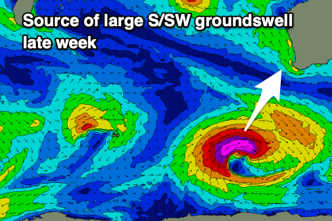
The source will be a strong low deepening rapidly south-west of us over the coming days, with it being the remnants of Tropical Cyclone Elvis off Madagascar, tracking south-east and into the westerly storm track.
While latish in our swell window we should see a fetch of severe-gale to storm-force W/SW winds generated in our south-western and southern swell windows, producing a shorter-lived pulse of S/SW groundswell for later Thursday and early Friday.
At the peak of swell the South West should see 8ft sets with Mandurah coming in more around 2ft+ thanks to the southerly direction, only 2ft max in Perth and into Friday morning.
Local winds will be strong out of the S/SE on Thursday, with Friday seeing weaker E/SE-SE winds through the morning creating the best conditions ahead of sea breezes.
Now, the weekend is tricky as a trough forms into a broad low and moves in Saturday, bringing SW winds but without any major strength.
The low may be sitting across us on Sunday along with some new mid-period SW swell generated by the low itself though the models diverge on this outcome.
EC has a broader trough and no swell at all so we’ll have another look at this on Wednesday and Friday.