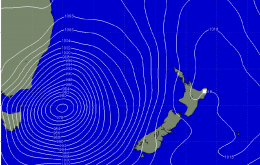
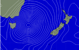
Small windows of opportunity in between strong onshores
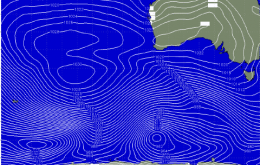
Give Saturday a miss and head South Sunday for fun clean waves around Middleton and Victor Harbor
Plenty of swell for this weekend and Tuesday/Wednesday but winds look to spoil the party aside for certain protected breaks.
Easing swells into Sunday, when a new swell should fill in and then back off into the middle of the week.
Easing swells into the weekend ahead of a new S/SW groundswell Sunday. From there on wave heights will ease as the trades freshen.
A deep upper cold pool in the upper atmosphere will provide the catalyst for the formation of a deep and powerful Tasman Low directly off our coast on Saturday.
This change will whip up a small south swell for exposed south facing beaches on Thursday, but it looks like the biggest beneficiary will be the Lower Mid North Coast, which should see an earlier influence from a building ridge of high pressure - fresh southerly winds at dawn winds are expected to go variable by lunchtime ahead of a late afternoon nor’easter.
A deep and powerful Tasman Low is expected to generate a large stormy S/SE swell over the weekend with associated S'ly winds. limiting surfing options to protected spots.
But at the peak of the swell Friday morning, much better E/SE winds are expected across most locations. Size wise we should see 6-8ft sets in the South West, 2ft to occasionally 3ft on the Perth, and 4-5ft up at Gero.
Oooh yeah, we’ve got a complex weekend for surfers and weather watchers alike. A developing low off the South Coast on Saturday morning - just east of Batemans Bay, according to the latest model guidance - will initially strengthen W/NW winds about the Sydney and Hunter regions, with more SW winds south of Wollongong and S/SW in the Far South.
Today's swell will ease through tomorrow and conditions are looking great for the South Coast with light morning offshores from the N/NW that will strengthen during the day. The Mid Coast will have waves early but conditions will deteriorate rapidly during the day.