Nothing major through the forecast period

Nias, Mentawai, South Sumatra forecast by Craig Brokensha (issued Thu 1st May)
Best Days: Every day although Tuesday and Wednesday morning will be small
Friday and the weekend (May 2 - 4)
Our recent run of solid S/SW groundswell should ease slowly through tomorrow and further into Saturday morning.
Size wise, the Ments should ease from 4-5ft+ at exposed spots with smaller surf around Nias and slightly larger waves around Southern Sumatra.
As we move into Sunday, a long-range S'ly groundswell is due, generated by a couple of vigorous polar fronts firing up on the periphery of our southern swell window, to the south-west of WA.
This swell should peak through the middle of the day/afternoon to 3-4ft+ around the Ments, with smaller surf towards Nias and larger waves again around Southern Sumatra.
Winds are expected to be generally light and variable into tomorrow and all weekend.
Next week onwards (May 5 onwards)
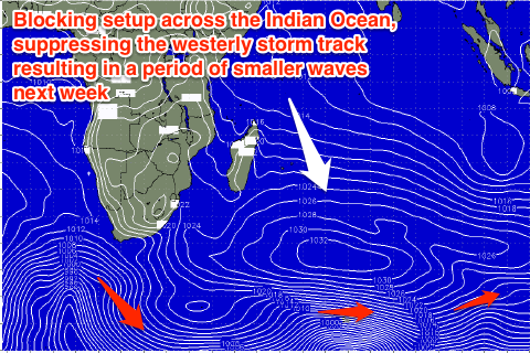 Into next week there's nothing major to report and as a result, wave heights will gradually tail away and bottom out Wednesday morning to 2ft to occasionally 3ft across exposed locations. This is a result of a large blocking pattern setup across the Indian Ocean (pictured right) suppressing polar frontal activity.
Small levels of background swell are due into the end of next week but only to 3-4ft+ or so and very inconsistent.
Longer term is a little tricky to make out at the moment, as a deepening tropical low drifting south-west from NW WA throws a spanner in the works regarding the make up of the westerly storm track in the Southern Indian Ocean.
We could see a solid new swell for the weekend of the 10th, but we'll review this again on Tuesday.