Improving options later week
Monday, 19 September 2022
Improving options later week
Monday, 19 September 2022
Large surf with dicey winds over the coming days, improving for all locations from Thursday.
Large surf with dicey winds over the coming days, improving for all locations from Thursday.
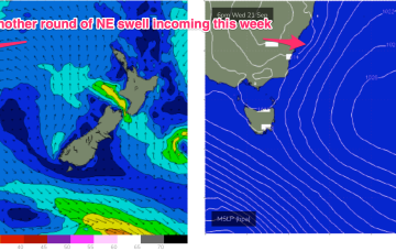
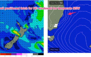
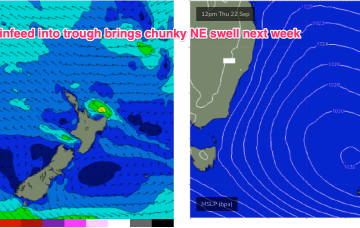
We have a typical looking Spring pattern with a weak high over the NSW interior and some flabby fronts passing South of Tasmania. An approaching trough series and inland low adds action mid-week as it tightens the pressure gradient with a more southerly located high, developing a N’ly fetch off the NSW Coast and another round of chunky NE windswell making landfall from mid week.
We have a typical looking Spring pattern with a weak high over the NSW interior and some flabby fronts passing South of Tasmania. An approaching trough series and inland low adds action mid-week as it tightens the pressure gradient with a more southerly located low, developing a N’ly fetch off the NSW Coast and another round of chunky NE windswell favouring the Mid North Coast for most size.
We have a typical looking Spring pattern with a weak high over the NSW interior and some flabby fronts passing South of Tasmania. An approaching trough series and inland low adds action mid-week as it tightens the pressure gradient with a more southerly located low, developing a N’ly fetch off the NSW Coast and another round of chunky NE windswell.
Lots of surfing opportunities across both regions this period with plenty of swell and varying, troughy winds.
There'll be plenty of options for a surf over the coming period with lots of swell and favourable winds for the beaches at times.
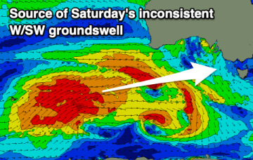
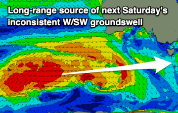
Nothing of note for the weekend in the South Arm, try further afield. Next week will consistent of inconsistent W/SW swells.
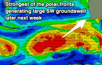
A tricky forecast for the South West as strong frontal activity continues well into spring. There'll be a couple of windows to target.
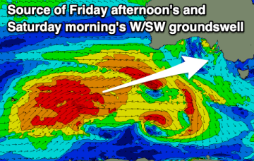
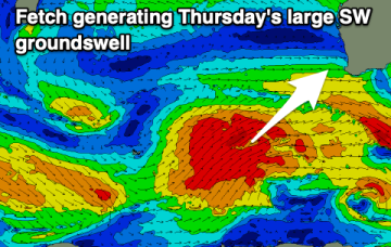
Still, no major change to the weekend f/cast. A complex low linked to multiple troughs and cold fronts is now approaching from SW of Tasmania. A main coastal trough linked to an Indian Ocean NW cloud band is clearing the area with a mostly NW flow across the weekend and a slowly easing NE swell on tap.
Still, no major change to the weekend f/cast. A complex low linked to multiple troughs and cold fronts is now approaching from SW of Tasmania. A main coastal trough linked to an Indian Ocean NW cloud band is clearing the area with a mostly offshore flow across the weekend and no major swell sources on tap.