Improving options later week

Western Australia Surf Forecast by Craig Brokensha (issued Monday September 19th)
Best Days: Perth early tomorrow for the keen, Thursday morning all locations, Friday morning all locations, Saturday morning all locations, Sunday morning Perth and Mandurah, Monday morning all locations
Features of the Forecast (tl;dr)
- Large mid-period SW swell tomorrow, a reinforcing pulse Wed with strong W/NW winds tomorrow (light N/NE early Perth), strong NW ahead of a late SW change Wed
- Large SW groundswell for Thu with S/SE tending S/SW winds in the South West, E/SE tending SW further north
- Easing large SW swell Fri with E/NE tending NW winds
- Smaller Sat with early variable tending SW winds
- Large, building mid-period SW swell Sun, holding Mon with S/SW winds in the South West Sun, (offshore further north), light E/NE Mon AM
Recap
The swell eased back in size on Saturday and conditions were bumpy across the South West with a moderate W/NW breeze that freshened through the day. Cleaner conditions were seen in Perth and Mandurah at dawn but with tiny surf.
Sunday provided a new pulse of SW groundswell with a window of cleaner but still lumpy conditions across the South West to 6ft+, 1-2ft in Mandurah and Perth. This was a little above expectations and we saw conditions deteriorate from midday as onshore winds kicked back in.
Today we've got a mix of new, building swells but with average winds across all locations that will strengthen and tend S/SW across all locations as a strong mid-latitude low pushes up and across us.
This week and weekend (Sep 20 - 25)
Ride out the next two days of surf and target the end of the week for a paddle across the state.
We've got a progression of strong mid-latitude and polar fronts currently occurring to our west-southwest and south-west, with the mid-latitude systems clipping us, bringing onshore winds.
Today's strong winds are due to an initial intense mid-latitude low firing up right off our coast, bringing the rapid jump in size, and we'll see this clear east tomorrow as secondary fronts move in, bringing strong W/NW winds.
There's a chance for early light N/NE winds across Perth in the morning before reverting back to the W/NW into the afternoon.
The localised swell from the mid-latitude low is due to ease as some new SW swell energy fills in, generated by a strong polar frontal progression over the weekend.
 Surf to 3ft is due in Perth and Mandurah, 8-10ft in the South West, similar Wednesday (if not a touch larger) with a reinforcing pulse of SW swell energy.
Strong NW winds will create poor conditions, giving into a late SW change, with Thursday looking much better as a high quickly fills in, swinging winds S/SE across the South West and SE further north with our largest pulse of SW groundswell.
This is being generated by gales being projected north-east towards us today and we should see 10-12ft surf across the South West, 4ft Mandurah and 3ft+ in Perth.
Friday morning looks excellent with the swell easing back from 10ft in the South West, 3-4ft across Mandurah and 2-3ft in Perth with E/NE offshore winds ahead of sea breezes.
 Moving into the weekend and there may be a window of light winds Saturday morning with a further drop in swell ahead of the next frontal system moving in through the afternoon.
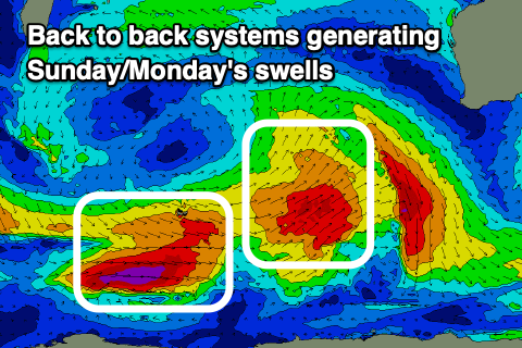
This front looks to be short-lived which is a plus, and it'll bring with it another large pulse of mid-period SW swell energy, prolonged in nature due to back to back fetches of strong to gale-force SW winds being projected towards us.
It looks like we'll see another swell in the 10ft range for the South West Sunday afternoon/Monday morning with 3-4ft sets in Mandurah and 3ft waves across Perth.
Winds look dicey for the South West Sunday and S/SW, offshore further north with sea breezes for the afternoon when the swell kicks in proper. Monday should be clean with an E/NE offshore ahead of sea breezes, possibly back onshore into the middle of next week. We'll have to have a closer look at this on Wednesday.