Good waves Tuesday ahead of large, stormy and onshore conditions Thursday onwards
Monday, 5 May 2014
Get in tomorrow if you're looking for clean fun waves, as conditions will deteriorate from Wednesday afternoon onwards.
Get in tomorrow if you're looking for clean fun waves, as conditions will deteriorate from Wednesday afternoon onwards.
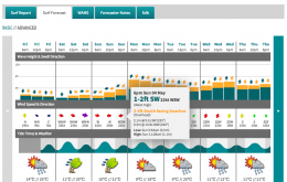
There’s no real change to Friday’s notes, with our current swell easing slowly through Tuesday (3-5ft south facing beaches, bigger in the Hunter but smaller at beaches not open to the south) ahead of two pulses of fresh south swell for Wednesday and Thursday.
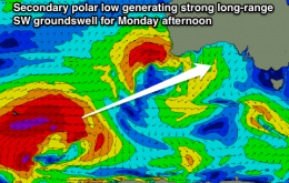
Good swell but not the best winds tomorrow, much better from Wednesday onwards, while next Monday is looking unreal.
Brief period of clean waves around Torquay tomorrow, with average waves expected until winds swing north-east on Thursday.
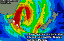
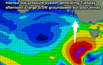
Winds off our coast should reach the gale to severe-gale-force range from the S'th, with an in-feed of S/SE winds to our south-east.
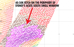
Now, model derived forecasts are an inexact science at the best of times. So if I were positioned somewhere between Port Mac and say, Yamba, about mid-afternoon on Sunday, I don’t think it’d be unreasonable to glance an expectant eye across the coast in hope of some early forerunners.
The size from the deepening Tasman Low off our East Coast has been downgraded with the system expected to sit just a touch too east, with the strongest winds sitting just out our swell window.
Good winds for the most part with Tuesday the pick of the period.
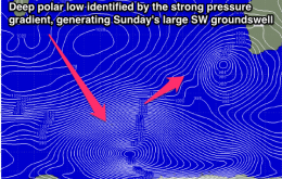
How's the synoptic charts, eh? As discussed ad nauseam all week, we’re looking at the development of a major low pressure system in the south-western Tasman Sea on Saturday.
Give Saturday a miss and head South Sunday for fun clean waves around Middleton and Victor Harbor