Windy end to the week, extra-large on the weekend

Western Australian Forecast by Craig Brokensha (issued Wednesday April 30th)
Best Days: Dawn tomorrow selected spots in the South West, Sunday morning and Monday morning Perth/Mandurah, Tuesday morning
Features of the Forecast (tl;dr)
- Moderate sized, inconsistent W/SW swell for later today, peaking tomorrow AM, easing
- Early, fresh NE winds, quickly strengthening from the N/NE through the AM, N/NW into the PM
- Strengthening N/NW-NW winds Fri with a building NW windswell (N/NE tending N/NW to the north)
- Large, late increase in swell Sat with strong W/SW-SW winds
- XL SW groundwell peaking Sun AM, easing
- Strengthening W/NW winds (variable E/NE-NE to the north early)
- Smaller Mon with fres S/SW winds (variable E/NE-NE to the north early)
- Large reinforcing SW groundswell Tue with E/SE tending S/SW winds
Recap
Perth and Mandurah were tiny yesterday with a small pulse of swell for the South West to the 4ft range, easing through the day.
Today is even smaller with clean conditions all over, while our secondary pulse of long-range W/SW swell is due later as winds swing more N’ly across the South West, variable onshore Perth/Mandurah.
This week and next (May 1 - 9)
Later today’s increase in inconsistent W/SW swell is due to peak tomorrow morning to 4-6ft across the South West and 1-1.5ft to the north, easing through the day.
The window for clean conditions looks limited though with early fresh NE winds due to quickly strengthen and shift N/NE, then N/NW into the afternoon.
This isn’t ideal at all with the inconsistent nature of the swell and northerly friendly breaks will be best.
Smaller surf is due Friday and the South West will see strengthening N/NW-NW winds for the get go, kicking up a stormy NW windswell with N/NE tending N/NW winds across northern locations.
This strengthening wind will be ahead of a significant polar frontal system pushing up and into us, under the influence of a strong node of the Long Wave Trough.
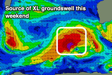
The Long Wave Trough essentially steers and strengthens storms to where it’s focussed and from later this week it will be focussed across the South West of the state.
The initial polar low linked to this initial and strongest push towards us is currently south-southwest of Western Australia, with it expected to project east and then north-east while expanding and strengthening tomorrow.
A fetch of severe-gale to storm-force W/SW-SW winds will be aimed directly towards us, producing a large, long-period SW groundswell for later Saturday, peaking Sunday.
The South West looks to come in at 15ft or so with 4-5ft sets in Mandurah and 3-4ft surf across Perth Sunday morning, easing during the day.
Local winds will be an issue though with strong W/SW-SW winds Saturday, strengthening W/NW on Sunday though the Perth and Mandurah region may see early, variable E/NE-NE winds. We’ll confirm this on Friday.
Depending on secondary activity through early next week, we may see winds go more S’ly on Monday across the South West, but more likely Tuesday along with a large, reinforcing pulse of SW groundswell.
This will be generated by a secondary, strengthening storm south-west of us Sunday/Monday morning, but the models diverge a little on this. Regardless it looks like the swell trend will be down from Tuesday with morning offshore winds as high pressure moves into the Bight.