Slow week, large and windy from the weekend

Western Australian Forecast by Craig Brokensha (issued Monday April 28th)
Best Days: Today, tomorrow, Wednesday and dawn Thursday in the South West
Features of the Forecast (tl;dr)
- Inconsistent small-mod sized W/SW swell tomorrow with fresh E/NE tending weaker N/NE winds
- Slightly better, inconsistent moderate sized W/SW swell later Wed, peaking Thu AM
- Fresh E/NE tending weaker N/NE winds Wed
- Strong, early NE tending N/NE then N/NW winds Thu
- Smaller Fri with strengthening N tending NW winds
- Large mid-period W/SW swell building Sat with strong W/SW tending SW winds
- Larger SW groundswell Sun, peaking in the PM with strong W/NW tending W winds
- Easing surf Mon with strong but easing W/NW tending SW winds
Recap
The South West was the pick of the regions over the weekend with slowly easing levels of swell under offshore winds. Saturday was the pick for the most size, a little smaller yesterday.
This morning the surf is smaller again but clean across the South West.
This week and weekend (Apr 29 - May 4)
As touched on in last week’s update, the coming week is fairly slow but with favourable winds for the coming days across the South West.
The first of two, inconsistent W/SW swells is due tomorrow, generated by a relatively small mid-latitude low to the south-east of South Africa last week, while a secondary slightly stronger pulse is due Wednesday afternoon/Thursday morning, generated by a slightly broader, longer lived low that formed south of South Africa.
Tomorrow’s should offer inconsistent 3-5ft waves across the South West with tiny surf to the north, with later Wednesday but more so Thursday morning coming in at 4-6ft in the South West, possibly 1-1.5ft in Perth/Mandurah.
Local winds tomorrow look fresh out of the E/NE, tending variable N/NE into the afternoon, similar Wednesday.
Thursday is tricky thanks to a significant polar frontal progression pushing up and into us with dawn NE winds due to strengthen quickly from the N/NE then shift N/NW into the afternoon.
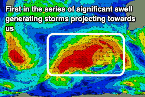
This strong and persistent frontal progression will be thanks to a strong node of the Long Wave Trough forming west of us later week, projecting and strengthening polar storms up and over us through the weekend and early next week.
With this we’re expected to see large back to back pulses of W/SW-SW groundswell mixed in with localised mid-period swell from each successive front.
Initially, a strong but tight low forming south of South Africa will generate a large but inconsistent long-range groundswell for Tuesday week, but the low itself will shed a significant polar storm which will race head of the long-range energy, with a great fetch of W/SW-SW gales due to project towards us from Wednesday through Friday.
This will produce a large close-range SW groundswell for Sunday, peaking into the afternoon with some large mid-period energy building ahead of it Saturday.
Size wise the South West looks to reach 10-12ft with 4ft surf across Mandurah and 3ft waves in Perth Sunday afternoon, though the coast will be under the influence of strong W/SW tending SW winds on Saturday and strong W/NW tending W winds on Sunday (possibly variable early Perth).
Depending on the developments of the next storm being projected up towards us we may see easing W/NW tending SW winds Monday, but the models diverge on all the secondary activity so check back here on Wednesday/Friday for a more accurate idea on what’s ahead.