Get out there today

Western Australian Forecast by Craig Brokensha (issued Monday April 21st)
Best Days: Today, selected spots tomorrow, Friday morning, Saturday morning in the South West, Sunday morning in the South West
Features of the Forecast (tl;dr)
- Large SW groundswell easing tomorrow with strong NE tending N/NE winds
- Smaller Wed with a building windswell under strong N/NW tending W/NW then W/SW winds
- Large close-range S/SW-SW swell Thu AM, easing with strong but easing S/SE winds
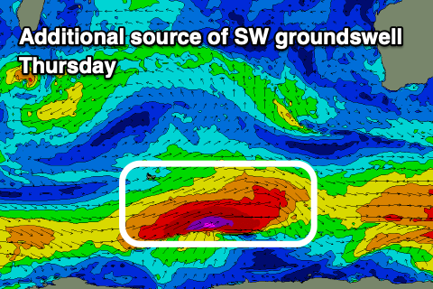
- Large SW groundswell in the mix Thu, easing Fri
- Mix of easing swells Fri with moderate E-E/NE winds ahead of sea breezes
- Moderate sized reinforcing S/SW swell Sat, easing Sun
- E/SE winds ahead of sea breezes Sat, E-E/NE Sun AM
Recap
The South West was the pick over the weekend with fun levels of background swell, cleanest through yesterday.
Today our large SW groundswell is on the build with clean conditions and great waves across the South West, fun in selected metro locations as well. We should see the South West reaching 8ft+ later today, 2-3ft Mandurah and 2ft+ across Perth as winds go variable.
This week and weekend (Apr 22 - 27)
Make the most of today as the current swell is due to peak overnight and ease through tomorrow as winds strengthen from the NE tending N/NE as a deepening mkd-latitude low moves in from the west.
This will bring strengthening N/NW winds tending W/NW then W/SW winds Wednesday as the low pushes in and across us.

The structure of the low is more south to north than west to east, with the swell potential off it not being great and aimed more towards Indonesia. In saying this we should still see 8-10ft of swell for early Thursday across the South West, 4ft or so Manudrah and 3ft Perth, easing rapidly along with strong but easing S/SE winds as the low clears east.
There should also be some large SW groundswell in the mix Thursday, generated by a strong polar low that’s currently east of the Heard Island region. This is generating a fetch of severe-gale W’ly winds, though the size looks to come under the localised swell.
Friday looks great with a moderate E-E/NE offshore along with easing levels of groundswell and S/SW energy to 4-6ft in the South West, 2ft Mandurah and Perth.
Into the weekend, the easing trend will be softened thanks to the arrival of some small reinforcing mid-period S/SW swell, generated by weak, poorly aligned frontal systems skirting around our swell window to the south-west of us mid-late week.
These swells will favour the South West with Saturday due to come in around 4-5ft, a bit smaller and fading Sunday.
Local winds look light out of the E/SE on Saturday morning ahead of sea breezes, then E/NE on Sunday.
Longer term most of next week looks small but we’ll have a closer look at this Wednesday.