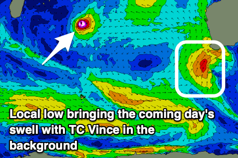
Large, windy swell followed by a proper groundswell
Western Australian forecast by Craig Brokensha (issued Monday February 10th)
Best Days: Protected spots to the north Wednesday morning, the South West Friday and Saturday mornings, protected spots next Monday, Tuesday morning in the South West
Features of the Forecast (tl;dr)
- Building, stormy windswell tomorrow with strengthening W/SW tending SW winds
- Large mid-period S/SW swell Wed AM, easing rapidly through the day and further Thu
- Strong S/SW winds Wed (possibly S-S/SE for periods to the north in the AM)
- Gusty S/SE winds Thu
- Small new mid-period SW swell Fri/Sat with E/SE morning winds ahead of sea breezes
- Large S/SW groundswell Mon AM, easing with strong S/SE-SE winds
Recap
Friday’s pumping surf eased back in size through Saturday with the South West offering the best waves under light offshore winds and with easing 4ft sets, tiny to the north.
Yesterday was a write-off with increasing onshore winds and tiny surf, while a small mid-period W swell has come up today with weak, workable onshore winds.
This week and weekend (Feb 11 - 16)
We’ve got a dynamic period of surf ahead with an initial mid-latitude low and close-range SW swell for the coming days due to be followed up by a large, strong SW groundswell early next week, with tropical origins.

Firstly, a deepening mid-latitude low directly south-west of us should bring with it strong to near-galeforce SW-S/SW winds, projecting across the state through tomorrow.
This will see strengthening W/SW tending SW winds tomorrow as the low moves up and across us, bringing with it some stormy, localised windswell while the larger mid-period SW-S/SW swell is due Wednesday morning to 8-10ft in the South West, 3ft Perth and 2ft+ Mandurah, easing steadily through the day.
Winds will unfortunately remain onshore and strong from the S/SW, with Perth and Mandurah likely seeing winds tend S-S/SE for a period through the morning.
Winds will then slowly improve and swing S/SE across the South West into Thursday but the swell will be on a quick decline through Wednesday with nothing of real size or energy due.
Into Friday and Saturday mornings, cleaner conditions are due along with some small, new mid-period SW swell. It’ll be generated by weak polar frontal activity with no size due across Perth and Mandurah while Margs should offer surf in the 4ft range.

Now, moving into next week we’re due to see a large S/SW groundswell impacting the state, generated by another tropical cyclone being absorbed into the westerly storm track.
This time it will be Tropical Cyclone Vince, with it currently in the middle of the Indian Ocean. We’re due to see it drop south-east through the end of the week while interacting with an approaching frontal system, resulting in the rapid deepening and expansion of a significant low south-southwest of us this weekend.
We should see a great fetch of severe-gale to storm-force winds generated through our south-western and then southern swell windows, with a large S/SW groundswell due Monday next week to the 10ft range in the South West, 2-3ft Mandurah and 2ft Perth. Winds look strong S/SE-SE at this stage but check back here on Wednesday for an update on the expected size and local winds.


Comments
Port Hedland could be in a bit of trouble here.
Hearing talk it could deepen to 920hpa and turn into a Cat 5...
B.O.M saying more than likely developing into a Cat 5, with possible direct hit on Pt Hedland tomorrow.
Hope all stay safe and get the hell outta there before it hits. Nasty stuff.