Average winds for the coming days, better next week

Western Australian forecast by Craig Brokensha (issued Friday January 31st)
Best Days: Keen surfers Perth/Mandurah Sunday morning, Tuesday morning, Wednesday morning
Features of the Forecast (tl;dr)
- Easing surf tomorrow AM with gusty S/SE winds and strong sea breezes
- Small-mod sized mid-period SW swell for later tomorrow, easing steadily Sun
- Fresh S/SE winds Sun ahead of strong sea breezes
- Late increase in mid-period SW swell Mon with strong S/SE tending stronger S-S/SW winds
- Large mix of mid-period SW swell and groundswell Tue, peaking in the PM, easing Wed
- Strong E/SE-SE winds ahead of sea breezes Tue, gusty E/SE Wed AM ahead of sea breezes
- Possible mod-large S/SW groundswell next Fri
Recap
Yesterday started a little slow but a good pulse of new SW groundswell kicked through the day, reaching 6ft in the South West just as sea breeze started to kick in, tiny to the north.
This morning the swell is still a good size thanks to some reinforcing mid-period SW swell moving in along with favourable winds for semi-protected spots in the South West, tiny to the north again.
This week and weekend (Feb 1 - 7)
Our current swell will ease into tomorrow morning across the region and conditions will be fairly average with a gusty S/SE breeze that will give way to strong sea breezes.
The South West should ease from 4ft with tiny waves to the north.
Later in the day but more so Sunday, a new pulse of mid-period swell is due, generated by a small, strengthening low tracking in from the west-southwest today.
Wind speeds look below gale-force and with this a weak mid-period kick in size is due 4-5ft+ later tomorrow, easing steadily from a similar size Sunday morning. Perth and Mandurah will be lucky to see 1-2ft sets and fresh S/SE winds will limit options Sunday morning ahead of strong sea breezes
Monday morning looks temporarily smaller ahead of a mix of large, late building mid-period swell ahead of some stronger groundswell into Tuesday, peaking through the afternoon.
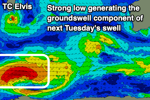
The source is a strong low that formed south of South Africa mid-week, with it projecting a fetch of W’ly gales (embedded bursts of severe-gales) slowly east. The low is now around the Heard Island region and is weakening slowly, with it due to continue to project east-northeast towards us on the weekend while slowly weakening.
A mix of mid-period swell from the closer-range (below gale-force winds) and less consistent groundswell from the stronger core fetch are expected, with the mid-period energy building late Monday afternoon, followed by the groundswell component on Tuesday.
The swell should peak in the 10ft range on the sets through the day Tuesday across the South West with Mandurah building to 3ft, 2ft to occasionally 3ft in Perth through the afternoon.

Conditions on Tuesday look decent though tricky with strong E/SE-SE winds across the South West, weaker to the north, with Wednesday seeing slightly weaker E/SE offshores as the swell eases.
Into the end of the week, we could see another pulse of strong groundswell across the region though more out of the S/SW.
The source will be the remnants of Tropical Cyclone Elvis, currently south of Madagascar, being absorbed into the westerly storm track.
This could see a strong polar low fire up to our south-west, but we’ll take a closer look at this on Monday. Have a great weekend!