Windy week with a couple swell pulses

Western Australian forecast by Craig Brokensha (issued Monday January 27th)
Best Days: Selected spots tomorrow morning in the South West, Thursday morning in the South West as the swell builds
Features of the Forecast (tl;dr)
- Small-mod sized mid-period SW swell for tomorrow with strong E/SE tending S/SW winds
- Easing swell Wed with strong SE winds ahead of sea breezes
- Moderate + sized SW groundswell building Thu, peaking into the PM, easing Fri
- Fresh SE tending strong S/SW winds Thu, S/SE tending S/SW Fri
- Strong S/SW-S winds Sat
- New mid-period S/SW swell Sun with S/SE tending S/SW winds
Recap
Following last week's funky NW swell, the weekend was fairly raw and average with a new spike in SW swell Saturday but with poor conditions in the South West, lumpy and not ideal to the north.
The swell backed off yesterday with slightly cleaner, peaky waves seen across the metro locations, bumpy and average in the South West again.
Today it’s even smaller with no real size around Margs, tiny and windswelly to the north.
This week and weekend (Jan 28 - Feb 2)
After the weekend’s average conditions we’ve got a slightly better week ahead for the South West while Perth and Mandurah look to be mostly a tease and only tiny in size.
A weak mid-period SW swell for tomorrow morning has been generated by a weak frontal system to our south-west the last day or two and should start to build this afternoon before peaking tomorrow morning.
No major size is due with the South West coming in around 4ft+ along with better, gusty E/SE offshore winds before sea breezes kick in. Perth and Mandurah will be tiny.
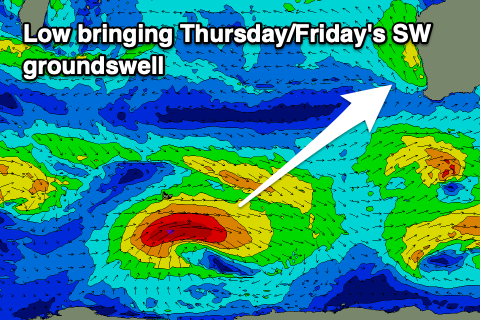
Wednesday will be smaller and less favourable thanks to SE winds in the South West, but coming Thursday/Friday, our new pulse of SW groundswell is still on track.
The source is a healthy polar low that’s currently around the Heard Island region with a tight fetch of W/SW gales due to generate a moderate sized pulse of energy for Thursday afternoon, peaking overnight and then easing Friday.
The projection towards us should help kick wave heights to 5-6ft across the South West Thursday afternoon with 1-2ft sets possible in Mandurah, tiny in Perth, then easing from 5ft and 1-1.5ft respectively Friday morning.
Winds on Thursday morning aren’t ideal and SE across the South West, S/SE to the north before strong sea breezes kick in, similar Friday and S/SE through the morning in the South West, more SE to the north ahead of sea breezes.
Moving into the weekend, and an approaching, deepening low looks to bring strong S/SW-S winds on Saturday along with small to moderate levels of mid-period energy.
The deepening low itself should generate a small spike of mid-period S/SW swell Sunday to 5ft or so in the South West and only 1-2ft across Mandurah as winds shift SE but remain strong. This isn’t ideal.
Longer term S/SE winds with moderate pulses of swell look to persist next week but we’ll have a closer look at this Wednesday.