Severe Tropical Cyclone Sean adds some flukey north swell to the mix

Western Australian forecast by Craig Brokensha (issued Monday January 20th)
Best Days: Selected spots Wednesday afternoon and Thursday morning, Friday afternoon in the South West
Features of the Forecast (tl;dr)
- Easing surf tomorrow with S/SE-SE winds ahead of sea breezes
- Small mix of mid-period SW swell and long-range W/SW groundswell building Wed, easing Thu
- Tricky moderate sized N/NW groundswell building Wed PM, easing Thu
- E tending S/SW winds in the South West Wed S/SE tending S/SW to the north
- Gusty S/SE-SE winds Thu AM ahead of sea breezes
- Small, inconsistent SW groundswell building Fri PM with E/NE tending N winds
- Slightly bigger mid-period SW swell Sat with fresh N winds, easing ahead of a W/SW change
Recap
Our large W/SW groundswell filled in through Saturday with a peak seen a little later than expected and into the afternoon.
Margs was large and raw with onshore winds into the afternoon, while Perth and Mandurah saw windows of morning offshore winds as the strong swell started to pulse.
Yesterday was the pick though with large, windy surf across the South West, easing back from 8ft+ across exposed breaks, 3ft Mandurah and 2-3ft in Perth.
Today the swell has really tailed off with Margs and Mandurah offering the best of it.
This week and weekend (Jan 21 - 26)
Following the weekend’s large surf which has tailed off into today, there’s not much in the way of reliable swell for the coming week.
Tomorrow will become smaller with less favourable, morning S/SE-SE winds across the South West (not ideal for the magnets), cleaner Wednesday morning but with no real size.
A very inconsistent, long-range and small W’ly groundswell is due to build through the day and peak Thursday morning though a closer-range mid-period SW swell looks to provide more consistent size.
Building sets to 3ft+ are due in the South West, tiny to the north but with sea breezes, easing from a similar size Thursday under gusty S/SE-SE morning winds.
Also in the mix Wednesday afternoon and Thursday morning should be some small, flukey cyclone swell from Severe Tropical Cyclone Sean. Sean is currently a category 3 system sitting just off the Exmouth coast and is due to move south-west, opening up select regions to an acute angled fetch of NW gales.
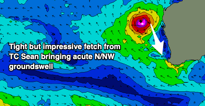
As Sean tracks more into our swell window it’s expected to ease but there should be enough of a fetch ot generate some decent size across breaks exposed to the north. The models are undercooking the size a little but north magnets in the Margaret River region may see 4-6ft sets Wednesday afternoon and Thursday morning while Perth and Mandurah aren’t expected to get much over 2ft. With the favourable winds for spots picking up the swell Thursday morning it’s worth a quick look but with low expectations.
Friday morning looks smaller under early offshore winds, while moving into afternoon, a new moderate sized pulse of SW groundswell swell is expected, ahead of some more consistent, bigger mid-period SW swell Saturday.
The sources will be a tight low that’s currently west of the Heard Island region, generating W’ly gales, followed by a strengthening frontal progression forming right on the back of the low, around the Heard Island region on Tuesday evening. This will direct a fetch of strong W/NW winds through our swell window into Wednesday and Thursday, generating Saturday’s swell.

Friday afternoon’s increase should build to 4-5ft across the South West with weak N winds, tiny to the north with Saturday’s coming in at 4-5ft+ with tiny waves persisting to the north.
Unfortunately an approaching trough on Saturday looks to bring fresh N winds ahead of a W/SW change, with lingering S/SW winds in its wake on Sunday.
Longer term, early next week looks cleaner but small while some better swell is likely later next week/weekend though with winds generally out of the south-east. More on this Wednesday.
Comments
https://www.weatherzone.com.au/news/wa-city-equals-its-hottest-day-of-49...
Can see 48.1 at Geraldton airport at 2:06pm today on BOM, with 15kt NE winds gusting 31kts at the time. Hot!
Edit: some simply stunning alliteration in the link above:
"Sizzling summer weather will persist in Perth throughout the working week, with top temps nudging 40°C."
Craig do you think there’s any chance of epic 3-4 foot waves along the Perth & Mandurah coasts from this cyclone swell? (like Marcus was 6-7 years back)
If not what’s the difference between the two swells?
Not Craig, but it looks like the storm track and intensity of swell is pointing more NNW than towards us,
That said, the heat wave we’re currently experiencing has hit well beyond forecast and I’m not a meteorologist but these conditions have been what have brought these tropical storms further south in the past…or at least we hope so.
Yeah with the south-west track at right angles to the swell window and then acute nature of the swell, I can't see it reaching that size, though we'll wait and see.
Thanks Craig, can you please put in an order with Huey for 2-3 foot peaks? Cheers
Forecast models are not epic but get ready anyway!
Indeed!
any updates is the swell hitting the window?
Here you go Macka.. https://www.swellnet.com/reports/forecaster-notes/western-australia/2025...
It's tricky but there's swell coming.
Swell getting into the normally placid Meelup Beach, north swell definitely getting in if you know where to make the most of it.
You still over there?
For a few more days
Unreal!!
Was actually the zone i was thinking might be worth a sniff with a bit of angle to the swell to give it some shape.