Cyclone swell inbound

Western Australian forecast by Craig Brokensha (issued Wednesday January 22nd)
Best Days: Selected spots later today and tomorrow, possibly Perth/Mandurah early Friday, Tuesday morning
Features of the Forecast (tl;dr)
- Moderate sized N/NW cyclone swell for later today and eary tomorrow
- Moderate sized reinforcing mid-period NW swell for later tomorrow and more so Fri, peaking into the PM, easing Sat
- Fresh E/SE-SE winds in the South West tomorrow AM, stronger S/SE into the PM (SE tending E winds ahead of sea breezes to the north)
- Strengthening N-N/NW winds Fri (N/NE early to the north)
- Smalll to moderate sized mix of SW groundswell and mid-period swell for Fri PM, peaking Sat AM
- NW tending SW winds Sat in Perth/Mandurah, variable W tending strong S-S/SW in the South West
- Easing swell Sun with strong S/SE tending S/SW winds
- Moderate sized mid-period SW swell building later Mon, peaking Tue AM with E/SE winds ahead of sea breezes
Recap
It’s been a hot couple of days with tiny, peaky surf across the metro regions, small and only for the keen across the South West.
This afternoon/evening we keep our eyes peeled for any sign of N/NW cyclone swell from Severe Tropical Cyclone Sean. Read below for more details.
This week and weekend (Jan 23 - 26)
We keen our eyes peeled for some flukey N/NW groundswell this afternoon and early tomorrow, generated by Severe Tropical Cyclone Sean which is now weakening east of Geraldton.
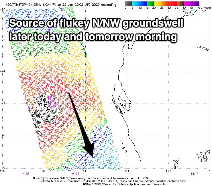
Through yesterday as STC Sean cleared the shadowing of the Western Australian mainland, a fetch of N/NW gales were generated though our northern swell window yesterday morning, with stronger storm-force winds recorded at its core by satellite (left).
The pros are the fetch strength, but the cons are the south-west track at right angles to our swell window and the small compact size of the fetch.
Regardless we should see see some quality swell hitting north magnets with the South West likely to reach 6ft with 2ft+ waves in Perth and 2-3ft waves across Mandurah either later today or early tomorrow morning.
Following this, with STC Sean now weakening east of Geraldton, it’s still maintaining a swell generating fetch of strong N/NW winds that will weaken further tomorrow but project south-southeast towards us into the evening and Friday morning.

This should produce a more noticeable NW swell for later tomorrow but more so Friday, kicking back to 4-6ft across the north magnets across the South West through the day with Perth seeing 2ft+ waves, 2-3ft across Mandurah again.
The swell looks to still be there on Saturday morning, easing through the day as the remnants of STC Sean moves across us, bringing with it a S’ly change.
Coming back to the local winds and tomorrow should see fresh E/SE-SE winds across the South West, stronger S/SE into the afternoon with SE tending E winds across metro locations ahead of afternoon sea breezes.
Friday then looks poor with strengthening N-N/NW winds in the South West (likely early N/NE across Perth/Mandurah) with NW tending SW winds Saturday across northern locations, variable tending strong S-S/SW in the South West.
Looking at other swell sources and a mix of inconsistent SW groundswell and mid-period energy are Friday afternoon and Saturday across the region, generated by an initial strong polar low followed by a weaker frontal system that’s currently south-west of us.
The South West should provide 5-6ft sets on Saturday, with the N/NW swell being more dominant across the metro regions, easing Sunday with strong S/SE tending S/SW winds.
Into next week a couple of strengthening fronts should generate some moderate sized mid-period SW swell pulses for Monday afternoon and Tuesday. The size at this stage isn’t anything special but it still looks fun with the South West likely to come in around 6ft with small 1-2ft sets to the north Tuesday morning under an offshore E/SE breeze.
We’ll confirm this on Friday.
Comments
Looks like Mandurah is starting to pick it up..
Rotto as well
Yup, tomorrow morning should be interesting.
I lived in Freo for 7 years and saw one of these swells. Was amazing to see the joint with that direction. The froth was insane. Hope there are a few bends in the beach for you all!
Nice little short to mid period energy should definitely produce some fun beachie peaks in the lesser frequented locations Sth of the metropolis zone. Bloody humid down here!! Which never happens!
It looks like late yesterday was the pick for the most consistent energy from the initial pulse.
Quality in Perth was very poor due to wind. You could see the N in some of the swell but it was still closing out :)
DS would be the pick today