Large to extra-large swells inbound

Western Australian Forecast by Craig Brokensha (issued Friday May 24th)
Best Days: Early Sunday selected spots Perth and Mandurah, Monday, early Tuesday Perth and Mandurah
Features of the Forecast (tl;dr)
- Large mid-period W'ly swell building Sat PM with a SW groundswell also into the PM
- Strong W/NW winds, tending weaker W/SW into the PM
- Large W/SW groundswell building Sun, peaking late with strong N/NW tending W/NW winds (possibly moderate N at dawn), moderate N/NE early to the north
- XL swell building Mon PM with variable S/SE-SE tending S/SW winds (N/NE tending NW to the north)
- Easing swell Tue with strengthening W winds (variable early to the north)
- Possible new swell Wed with strong W/NW winds
Recap
A slightly stronger pulse of W/SW swell was seen through yesterday with clean conditions early across Margaret River, becoming wind affected into the afternoon.
This morning the swell has faded and with unfavourable, increasing north winds.
This weekend and next week (May 25 - 31)
Today’s freshening northerly wind is associated with an approaching frontal system that’s due to bring our first large pulse of W/SW swell for Sunday.
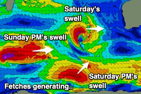
Ahead of this though a couple of moderate to large pulses of W/SW and SW groundswell are due tomorrow, generated by a mid-latitude low and consecutive polar low during the week.
The W/SW energy is due to build through tomorrow and reach 6-8ft into the afternoon with 2-3ft sets across Perth and Mandurah, with the SW groundswell coming in around a similar size.
Winds will be poor though and strong from the W/NW tending weaker W/SW as the approaching front pushes through.
Sunday will see the large WSW groundswell building into the afternoon, kicking further to 10ft+ across the South West, 3-4ft in Mandurah and 2-3ft across Perth.
Winds early, ahead of the swell should be N/NE and light to moderate across Perth and Mandurah, possibly N’ly in Margs but quickly shifting N/NW and strengthening, then W/NW into the afternoon.
Sunday afternoon’s swell is due to hold a similar size early Monday and we’re looking at variable winds across the state as the next swell producer dips away to the south-east.
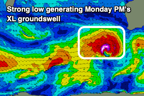
This swell producer will be a significant low, with a fetch of severe-gale to storm-force W/SW winds due to produce an XL groundswell for the afternoon Monday, kicking to 15ft in the South West, 4ft Mandurah and 3ft Perth.
Light S/SE-SE tending weak S/SW winds are due across the South West with N/NE tending NW winds to the north, strengthening into Tuesday as the next frontal systems moves in.
Perth and Mandurah should see variable winds early Tuesday and the XL pulse of swell for Monday afternoon is due to ease back from 10-12ft, 3ft+ and 2-3ft respectively.
The models diverge regarding the next front moving in on Tuesday, and the resultant kick in size, but in any case it looks like onshore winds will spoil it, with easing surf and W-NW winds due into the end of the week.
Longer term more frontal activity and large to XL surf is on the cards for next weekend, but more on this Monday. Have a great weekend!
Comments
Thanks F*CK...longest swell drought in history!