Fun surf in metro locations tomorrow morning, with a larger swell later week

Western Australian Surf Forecast by Craig Brokensha (issued Monday January 22nd)
Best Days: Today ahead of sea breezes, tomorrow morning Perth and Mandurah, Thursday morning protected spots, Friday morning, Saturday morning
Features of the Forecast (tl;dr)
- Small-mod sized W/SW swell for this arvo, easing tomorrow with SW winds in the South West, S/SE-SE to the north
- Small Wed with similar winds
- Large SW groundswell for Thu, peaking during the PM with gusty S/SE winds, strengthening and tending strong S/SW to the north
- Easing SW swell Fri with mod-fresh SE tending strong S/SW winds
- Smaller Sat with fresh E/SE tending S/SW winds
Recap
The weekend was average surf wise with small, easing swell on Saturday though clean in the morning, bottoming out yesterday with morning offshores again.
A small pulse of W/SW swell due today and tomorrow started off slow this morning but a few more sets to 1-2ft are now showing across the metro locations with favourable winds. Margs is still small and bumpy with average winds.

New lines of west swell showing
This week and weekend (Jan 23 – 28)
Today's building W/SW swell should hold into tomorrow morning across all locations before easing into the afternoon.
The source was a weak, slow moving mid-latitude low to our west-southwest and surf to 2ft should be seen across Perth tomorrow morning, 2ft to occasionally 3ft Mandurah and 3-5ft across the South West, easing through the day.
Winds will remain onshore from the SW across the South West with better S/SE-SE breezes to the north in the morning before strengthening from the SW into the afternoon.
Similar winds are due into Wednesday morning but with smaller surf.
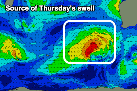
Looking at the end of the week and a larger SW groundswell is now on the cards for Thursday, generated by a healthy, strengthening front projecting up towards us over the coming days.
The front has formed around the Heard Island region and will project a fetch of strong to at times, gale-force W/SW-SW winds towards us, clipping the state Wednesday, though persisting Thursday thanks to its slow movement.
A large, prolonged SW swell is due, strongest on Thursday and peaking to 8ft to occasionally 10ft across the South West, building to 3ft in Mandurah and 2-3ft in Perth. The easing trend will then be slow with fun, dropping sets from 6ft to possibly 8ft in the South West Friday, 2-3ft to the north.
Winds will start to improve on Thursday but only be favourable for protected spots with fresh to strong S/SE breezes, stronger into the afternoon and S/SW to the north.
Friday looks cleaner with a fresh SE offshore before sea breezes kick in, smaller Saturday but cleaner again.
Longer term the outlook remains more active with more swell on the way for next week with what looks to be favourable winds. More on this Wednesday.