Average surf outlook continues though the metro locations should offer something

Western Australian Surf Forecast by Craig Brokensha (issued Friday January 19th)
Best Days: Metro locations Monday and Tuesday morning, protected spots next Thursday and Friday morning
Features of the Forecast (tl;dr)
- Fading SW groundswell tomorrow with S/SE-SE tending strong SW-S/SW winds
- Small Sun with S/SE tending strong SW winds
- Small, weak W/SW swell for Sun PM, building further Mon, easing Tue
- SW winds in the South West Mon AM, S/SW-S Tue AM
- S/SE winds Mon AM Perth and Mandurah, stronger S/SE Tue AM
- Moderate sized mid-period SW swell building Thu, peaking in the PM, easing Fri
- Strong S/SE-SE winds Thu AM, strong SE Fri AM
Recap
Average surf the last two days with onshore winds yesterday and a building windswell, a touch cleaner but still well below par today with cross-shore winds in the South West. An inconsistent groundswell due in the South West isn't making much of an impact at all unfortunately, not that conditions are favourable.
This weekend and next week (Jan 20 – 26)
Any little swell seen today is due to ease into the weekend with a S/SE-SE breeze tomorrow morning before strong S/SW-SW winds kick in, less favourable and S/SE on Sunday morning, strengthening from the SW through the day again.
Without any major swell sources, local windswell generated by the strong afternoon winds will be the only real noticeable energy in the water.
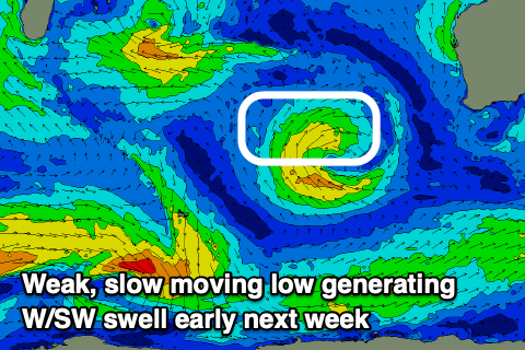
As touched on in Wednesday's notes, a slow moving mid-latitude low that's currently sitting north-east of the Heard Island region is generating a small fetch of strong W/SW winds through our western swell window. The low will continue to do so while moving further east on the weekend, breaking down on approach through early next week.
The slow movement will produce a prolonged, small W/SW swell that's due to arrive Sunday but more so Monday, peaking into the afternoon and easing slowly Tuesday.
Perth should see fun 2ft+ surf with 2-3ft sets across Mandurah and 4-5ft waves across Margs at the peak of the swell.
Local winds on Monday look best for the metro locations, tending S/SE in the morning with SW breezes to the south - developing across all locations through the day.
Tuesday looks windy cross-shore with gusty S/SE winds across the metro locations, S-S/SW in the South West. So all in all Perth and Mandurah look best for this incoming swell with the cleanest conditions.

Similar winds look to play out on Wednesday as the swell fades.
Longer term, a weak frontal system projecting towards us during early next week should produce a moderate sized pulse of mid-period swell for Thursday afternoon which at this stage looks to build to 4-6ft or so in the South West, 2ft in Mandurah and 1-2ft across Perth, easing Friday.
Conditions will be a little wind affected but doable with strong S/SE-SE winds through Thursday, strong SE Friday morning as the swell eases.
Following this, a stronger cold outbreak may be on the cards generating larger surf into the following week. More on this Monday. Have a great weekend!