Average end to the week/weekend, good early next week

Western Australian Surf Forecast by Craig Brokensha (issued Wednesday December 13th)
Best Days: Monday morning, Tuesday morning in the South West and Mandurah
Features of the Forecast (tl;dr)
- Easing surf into the end of the week and weekend, slowly a little thanks to pulses of mid-period SW swell
- Gusty SE winds tomorrow AM (S/SE to the north), SE Fri AM
- Fresh E/SE winds Sat AM, strong S/SE-SE Sun AM
- Large SW groundswell peaking Mon AM, easing into the PM and further Tue
- Strong SE winds ahead of strong sea breezes Mon (possibly E/SE at times in the South West in the AM, E/SE to the north)
- Fresh E/SE winds Tue AM
Recap
Some new W/SW swell arrived a few hours early yesterday with clean conditions through the morning and good 4ft waves in the South West, 1-1.5ft to the north, building into the afternoon but with sea breezes.
This morning the swell held with cross-offshore winds and 4ft+ sets across the South West, 2ft in Mandurah and 1-2ft across Perth.

Good surf this morning
This week and weekend (Dec 14 - 17)
The end of the week looks average as the current swell eases with gusty SE winds tomorrow morning in the South West, S/SE to the north ahead of strong sea breezes, SE everywhere on Friday morning but with no decent swell. Some small, background mid-period energy isn't expected to top today's size.
The easing trend will continue into the weekend with slightly more favourable winds, swinging E/SE through the morning on Saturday, reverting back to the S/SE-SE on Sunday.
Of greater importance is the SW groundswell due into Monday across the state, with the low generating it looking a touch stronger than forecast on Monday.
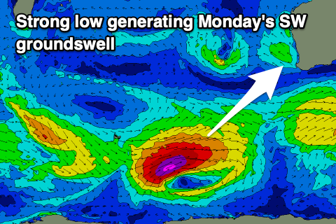
The polar low linked to the swell will form around the Heard Island region tomorrow morning, deepening and then projecting a fetch of severe-gale to possibly storm-force W/SW winds through our south-western to southern swell window before weakening Saturday.
We'll see the swell arriving overnight Sunday, peaking Monday morning to a strong 8ft to occasionally 10ft on the magnets in the South West, 2-3ft across Mandurah and 2ft in Perth.
It'll be wind but with strong SE winds that may tend E/SE at periods in the South West, E/SE to the north ahead of strong sea breezes, with easing surf Tuesday with a great, fresh E/SE offshore. Perth and Mandurah look small to tiny with easing 4-5ft sets in the South West.
Longer term there's nothing significant on the cards so make the most of the swell early next week.