Average weekend, small windows for next week and weekend

Western Australian Surf Forecast by Craig Brokensha (issued Friday October 20th)
Best Days: South West today and magnets early tomorrow, Tuesday South West magnets, Saturday week
Features of the Forecast (tl;dr)
- Easing surf tomorrow with freshening E/NE-NE tending N/NE winds, ligher N into the PM
- Strengthening S/SW-SW winds Sun with a building windswell and small W'ly swell
- Easing W and S swells Mon with S/SE tending S/SW winds
- Inconsistent, small-mod sized mid-period SW swell Tue with strong E/SE winds, tending variable
- Easing surf Wed with gusty E/NE-NE tending W winds
- Moderatae + sized mid-period SW swell for next Saturday with E/NE-NE tending NW winds
Recap
Yesterday started slow across all locations but with clean conditions and a new pulse of SW swell pushed in nicely through the day, exceeding expectations a little in the South West and reaching an easy 6ft. To the north sea breezes got to the building swell, with smaller, slower easing 1-2ft waves today. The South West was still 5ft and nice and clean.

Still fun ones this morning to 5ft
This weekend and next week (Oct 21 - 27)
The current swell will continue easing into the weekend and early E/NE-NE winds tomorrow will freshen from the N/NE later morning before easing and holding from the N'th. Hit the South West magnets for a small wave, while the metro locations will be tiny.
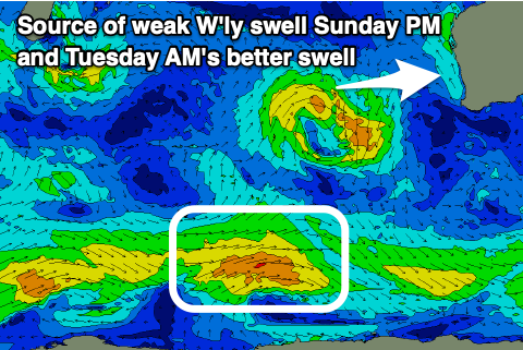
Sunday looks to be a lay day with fresh SW tending S/SW winds as a weak trough clips us. As it moves through, a small pulse of weak W'ly swell will build with the developing onshore winds, generated today on the northern flank of the trough before it weakens.
Don't expect anything of quality but the metro locations look to build to 1-2ft along with strengthening SW winds. The trough was expected form into a low south of us on Monday, kicking up a small, weak S'ly swell but this has been downgraded.
This will see winds go back to the S/SE on Monday but with a weak S'ly swell, while come Tuesday an inconsistent background SW swell should offer a better opportunity for a surf.
This swell has been generated by fetches of strong to near gale-force W'ly winds on the polar shelf and a boost to an inconsistent 4-5ft is due on the South West magnets, tiny to the north and with strong E/SE winds that look to tend variable into the afternoon.

Make the most of this window of surf as Wednesday looks smaller and easing with gusty E/NE-NE winds, easing and tending N/NE before shifting W into the afternoon as another trough clips the state.
As touched on in the last forecast, some better swell is due into later Friday/Saturday but the storm linked to this swell has been downgraded with a much weaker fetch of winds moving through our swell window. This has resulted in a downgrade of the swell, with it being mostly mid-period energy, peaking Saturday week to the 6ft range in the South West, 2ft Mandurah and 1-2ft across Perth.
Winds are tricky but look to be light offshore in the morning but we'll have to confirm this on Monday. Longer term there's still nothing major on the cards but check back here Monday. Have a great weekend!