Good surf into the middle of the week

Western Australian Surf Forecast by Craig Brokensha (issued Monday September 25th)
Best Days: Tomorrow morning, Wednesday, Friday morning for the keen
Features of the Forecast (tl;dr)
- Easing W/SW swell tomorrow with variable tending onshore winds late AM
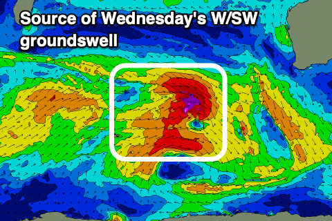
- Large W/SW groundswell Wed with E/NE tending N/NE then variable winds
- Easing swell Thu with mod-fresh S-S/SE tending S/SW winds
- Smaller Fri with S/SE tending S/SW winds
- W/NW winds Sat with a building swell
- Larger, building surf Sun with strengthening NW winds
- Oversized swell Mon/Tue with strong W/SW winds Mon, SW Tue
Recap
Average conditions on Saturday gave way to pumping surf yesterday as a large, long-period W/SW groundswell filled in under offshore winds.
The South West topped out in the 10ft range, 3ft across Mandurah and 2ft in Perth, while this morning conditions were clean early with an easing swell, but a trough has since brought an onshore change.

Large sets yesterday PM
This week and weekend (Sep 26 – Oct 1)
It’s great to be back in the saddle after a couple of weeks offline, and looking at the week ahead, the current swell will continue to ease into tomorrow ahead of the next pulse of decent energy on Wednesday.
Winds look variable tomorrow morning across the South West, with light offshore winds to the north, shifting onshore later morning as a trough moves in.
Moving into Wednesday and a new moderate-large pulse of W/SW groundswell is due across the state, generated by a great fetch of gale to severe-gale W/NW winds firing up north-east of the Heard Island last night. This fetch will move east-southeast today and break down overnight, leaving the swell to travel onwards, arriving Wednesday and peaking through the day.
The South West should kick back to 6-8ft with 2-3ft sets developing in Mandurah and 2ft waves across Perth under morning E-E/NE winds. Winds are due to tend more N'ly through the day but then go variable offering a full day of fun surf.
The swell should ease back through Thursday as winds deteriorate thanks to a trough slipping through during the evening Wednesday. This will leave unfavourable S/SE-S winds across most locations, shifting more onshore during the day.
A slight improvement in winds is due Friday, tending S/SE in the morning but with smaller, easing surf.
The weekend should see the surf starting to build again as a progression of not overly substantial frontal systems push up and across us.
This will be with onshore winds on Saturday as the first front moves through, strengthen further into Sunday/Monday as the bulk of the progression moves up and across us.
It looks to be a slow moving progression resulting in large surf building through Sunday, further Monday and peaking into the evening if not Tuesday morning.
The South West looks to reach the 12ft+ range at this stage but winds look onshore for the duration of the peak, lingering as it eases.
We'll have a closer look at this on Wednesday though.