Make the most of today and tomorrow in the South West

Western Australian Surf Forecast by Craig Brokensha (issued Wednesday August 30th)
Best Days: Today in the South West, tomorrow in the South West, Perth and Mandurah early Friday, Perth and Mandurah next Wednesday
Features of the Forecast (tl;dr)
- Moderate sized + mid-period SW swell building tomorrow, peaking Fri
- Mod-fresh E/NE tending lighter N/NE winds tomorrow, strengthening NW tending W/NW Fri (variable early Perth and Mandurah)
- Strengthening W/NW winds Sat
- Oversized W/SW groundswell for Sun with strong SW tending W/SW winds
- XL, stormy SW swell Mon with strong W/SW winds, easing Tue with fresh W/NW winds
- Easing surf Wed with W winds in the South West, light offshore to the north
Recap
Yesterday morning started bumpy and wind affected across the South West but improved as the day went on, thanks to a high moving in behind Monday's trough, swinging winds more offshore. The swell was still a fun 4-5ft with 1-2ft waves across Mandurah, 1-1.5ft in Perth with peakier conditions.
Today the surf is super clean and we've got a bit more energy than expected hanging in the South West with slow but good 4-5ft sets on the magnets, tiny to the north and mostly to 1-1.5ft.

Good sets hanging in the mix today
This week and weekend (Aug 31 – Sep 8)
The surf should begin to build again through tomorrow as some new mid-period SW energy arrives, followed by a peak on Friday.
The source of this swell is a healthy polar frontal system that's currently to our south, generating a fetch of strong to gale-force W'ly winds. Over the past two days though it was positioned in our south-western swell window with similar strength, and we should see building sets to 4-6ft across the South West, peaking Friday to 5-6ft with Mandurah peaking Friday to 2ft, with 1-2ft sets across Perth.
Winds will be best for the South West tomorrow though with a moderate to fresh E/NE tending variable N/NE breeze, poor Friday thanks to strengthening NW tending W/NW winds. Perth and Mandurah should offer early variable winds on Friday before shifting NW late morning.
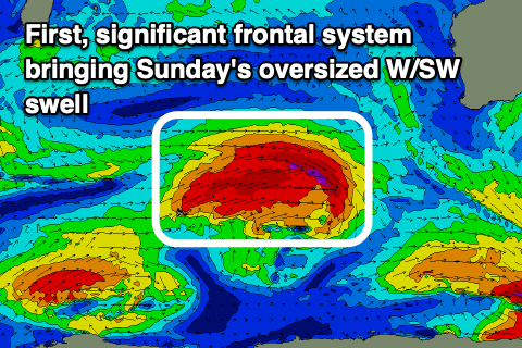
The shift in winds will be thanks to a weak front clipping us ahead of a much more significant frontal progression moving in through the weekend, bringing an XL, stormy swell through Sunday/Monday.
Firstly, Saturday looks to remain similar in size to Friday with onshore W/NW winds across all locations, strengthening through the day as the first frontal system moves in.
This front is forming west of the Heard Island region today and will project a fetch of W/SW gales slowly towards us over the coming days, weakening while moving into us Saturday evening.
An oversized, long-period W/SW groundswell is expected from this first front on Sunday, pushing to 12ft+ in the South West, 4-5ft across Mandurah and 4ft in Perth but with strong SW tending W/SW winds.

The secondary system will quickly move in behind the first, directing an additional fetch of gales up and into us Saturday evening through Sunday, boosting the swell to the XL size later Sunday but more so Monday with 15-20ft surf due in the South West, 4-5ft+ across Mandurah and 3-5ft in Perth.
Unfortunately winds will remain onshore Monday and Tuesday as the swell eases, out of the W/SW on the former and W/NW on the latter, with Wednesday likely to see light variable winds across Perth and Mandurah but with easing 2-3ft sets in Mandurah, 2ft across Perth.
Longer term there's some new swell with onshore winds due into the end of the week, but check back here on Friday for more on this.