Mixed conditions though clean for the coming days in the South West

Western Australian Surf Forecast by Craig Brokensha (issued Monday August 28th)
Best Days: Tomorrow morning in the South West and Wednesday morning for the desperate, Thursday (afternoon Perth and Mandurah), Tuesday morning next week Perth and Mandurah
Features of the Forecast (tl;dr)
- Inconsistent S/SW groundswell building today, easing tomorrow with E/SE tending fresh S/SE winds
- Smaller Wed with similar winds
- Moderate sized, mid-period SW swell building Thu with fresh E/NE tending light N winds. easing Fri with strengthening N/NW tending W/NW-NW winds
- Strong W winds Sat, stronger Sun with an XL, building stormy swell, peaking Sun
- Easing swell Mon with strong W winds, weaker Tue (light E to the north)
Recap
Clean conditions but with a small, fading swell across the South West on the weekend, tiny to the north but also clean.
Today remains small and onshore, with a trough stalling a little resulting in lingering S/SW winds across the South West, cleaner to the north but tiny.
This week and weekend (Aug 29 – Sep 3)
Today's new S/SW groundswell looks to be a little under expectations and winds didn't play ball across the South West this morning as a trough lingered in the region.
Tomorrow will be much cleaner with an E/SE offshore across the South West and hopefully still a bit of swell in the tank, easing back from 3-5ft across the magnets, tiny to the north.
The swell will ease through the day as winds shift S/SE, so surf in the morning.
Wednesday will become smaller with similar E/SE tending S/SE winds.
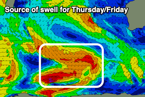
Moving into Thursday and some new, building mid-period swell and offshore E/NE tending variable N winds should provide fun surf.
The source of this mid-period swell building Thursday, peaking Friday is a broad but relatively weak and easing fetch of strong to gale-force W'ly winds around the Heard Island region today, weakening on approach to us over the coming days.
This should see building surf to 4-5ft across the South West, peaking to 5-6ft Friday morning, then easing, with a peak to 2ft across Mandurah and 1-2ft across Perth.
Winds on Friday will unfortunately deteriorate quickly as a significant mid-latitude low forms right off our coast, bringing strengthening N/NW tending W/NW-NW winds.

The low will actually begin its life as a strong frontal system just north of the Heard Island region, projecting east-northeast while producing a good fetch of W/SW gales.
Winds are due to reach the severe-gale range as the low deepens off our south-west, bringing an XL, stormy increase in SW swell on the weekend, peaking Sunday. At this stage the South West looks to reach 15ft+, 4-5ft across Mandurah and 3-4ft in Perth along with strong W winds on Saturday, even stronger Sunday and tending more W/NW.
Monday will remain poor as the low remains slow moving, with strong W/SW winds due, lingering onshore Tuesday as the swell drops steadily. Perth and Mandurah should see lighter offshore winds Tuesday morning and still plenty of size.
Unfortunately it looks like frontal activity will continue into the end of the week and next weekend, but check back here on Wednesday for more details.